
Ohio Faces Potential January Record Heat as Temperatures Surge Into the 60s From Toledo to Cincinnati on Friday
OHIO — A rare January warm-up is set to sweep across Ohio on Friday, with record-breaking temperatures possible from northwest to southern parts of the state, according to forecast data. Cities including Toledo, Cleveland, Columbus, and Cincinnati could see highs climb into the upper 50s and low 60s, levels more typical of early spring than mid-winter. The surge of warm air is expected to arrive early in the day, giving Ohio an unusually mild end to the workweek.
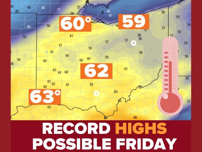
Record Highs Could Be Challenged Across Northern and Central Ohio
Forecast maps show high temperatures near 60°F in northern Ohio, including the Toledo and Cleveland areas, with low 60s expected farther south toward Columbus and Cincinnati. One of the most notable records at risk is Toledo’s long-standing January record of 59°F, which was set 146 years ago and could be tied or broken if temperatures rise as expected. Such widespread warmth across the state in January is uncommon and highlights the strength of the incoming warm air mass.
Spring-Like Feel Will Come With Rain and Gusty Winds
Despite the warmth, conditions will not be entirely calm. Widespread rain showers and gusty winds are expected, adding to the spring-like atmosphere but potentially creating slick roads and reduced visibility at times.
Forecasters note that while sunshine may be limited, the combination of warm temperatures, rain, and wind will make it feel far removed from typical winter weather.
A Brief Taste of Spring Before Winter Returns
This warm spell is expected to be short-lived, serving as a temporary break from winter before colder air eventually returns. Residents are encouraged to stay weather-aware, especially during periods of rain and gusty winds, and to take advantage of the mild conditions while they last.
Stay connected with NapervilleLocal.com for continued coverage of major weather shifts across the Midwest, record temperature threats, and clear explanations of what these unusual patterns mean for the days ahead.

I’ve lived in Naperville long enough to see how quickly our community changes — from new developments downtown to sudden shifts in our Midwest weather. Reporting on Naperville news and daily forecasts gives me the chance to keep neighbors informed about what really matters. My goal is simple: deliver clear, timely updates so you always know what’s happening in our city and what to expect from the skies above.