
Strengthening Upper-Level Trough Signals More Impactful Weekend Weather for Midwest and Eastern U.S., With Winds Increasing but Plains Staying Mostly Dry
CENTRAL AND EASTERN UNITED STATES — A developing winter weather system expected this weekend is trending stronger in the upper atmosphere, according to the latest ECMWF guidance, but it is also organizing later than a typical winter storm, which will sharply limit precipitation across much of the central Plains while increasing impacts farther east.
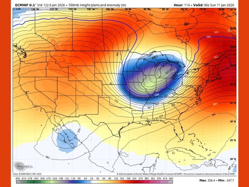
The newly updated 500mb (upper-level) pattern shows a more consolidated and deeper trough, with colder colors tightly clustered together — a sign of a stronger system aloft. However, because this trough takes longer to fully organize, the Plains are likely to miss out on significant snowfall or rainfall altogether.
Why a Stronger Trough Doesn’t Mean Widespread Snow
Despite the system strengthening, the delayed organization means moisture return and surface development lag behind the upper-level energy. As a result, large portions of the Plains remain on the dry side of the system, with little to no precipitation expected in those areas.
Forecasters emphasize that this is a classic case of strong dynamics without optimal timing, where impressive upper-level structure does not automatically translate into widespread snow.
Increasing Wind Potential as the System Tightens
One key takeaway from the latest data is the wind threat. A stronger trough aloft typically leads to stronger surface pressure gradients, and this system is no exception.
As the system matures, gusty winds are increasingly likely, especially across parts of the Midwest, Great Lakes, and into the Ohio Valley. Even where snowfall remains limited, wind-driven impacts could still make conditions feel more intense, particularly for travel and outdoor activity.
Midwest and Ohio Valley Could See the Greatest Impacts
While the Plains stay mostly dry, the Midwest and eastern U.S. sit closer to the core of the upper-level energy, placing them in a more favorable position for active weather. Exact snowfall placement will depend on how quickly surface features respond, but the potential for a more impactful system is growing as guidance continues to trend stronger. Forecasters note that snowfall details are still evolving, and small shifts in timing could significantly change where precipitation ultimately falls.
What to Watch Over the Next Few Days
Key factors to monitor include:
- How quickly the trough fully organizes
- Whether surface low pressure develops faster than currently projected
- The strength of winds as the pressure gradient tightens
- Any eastward or westward shift in the system’s core
As confidence increases, impacts may become clearer — but for now, the message is stronger system, limited Plains precipitation, and increasing wind concerns.
For continued updates on this developing weekend system, evolving Midwest impacts, and how changing upper-level patterns could affect travel and daily life, stay with NapervilleLocal.com for clear, data-driven weather coverage.

I’ve lived in Naperville long enough to see how quickly our community changes — from new developments downtown to sudden shifts in our Midwest weather. Reporting on Naperville news and daily forecasts gives me the chance to keep neighbors informed about what really matters. My goal is simple: deliver clear, timely updates so you always know what’s happening in our city and what to expect from the skies above.