
North Carolina Faces Multiple Rounds of Rain and Thunderstorms as Slow-Moving Cold Front Arrives Friday Into Saturday
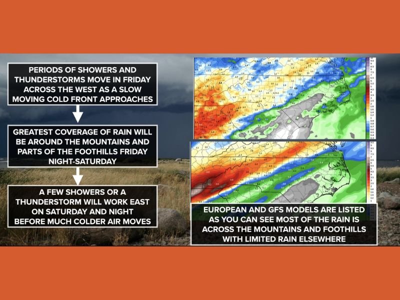
North Carolina — A slow-moving cold front approaching the state will bring periods of showers and thunderstorms from Friday into Saturday, with the highest rain coverage expected across the mountains and foothills, according to the latest forecast guidance. The system will gradually increase moisture and instability, especially across western North Carolina, as it approaches late Friday.
Meteorologists say central and eastern North Carolina will see more limited and scattered rainfall, mainly later on Saturday. The overall setup favors multiple rounds of rain rather than a quick-moving storm system.
What the Weather Pattern Looks Like Heading Into the Weekend
The weather pattern is being driven by a slow-moving cold front, allowing rain chances to linger longer than usual, particularly west of the Piedmont. Forecast models show showers developing Friday afternoon and evening across the mountains and foothills, with thunderstorm chances increasing Friday night.
As the system progresses, activity will shift east late Saturday into Saturday night, followed by the arrival of much colder air behind the front. This evolution supports repeated rain bands instead of a single line of storms.
Friday: Rain and Storms Focused West, Limited Impact Elsewhere
On Friday, scattered showers are expected to move into the mountains and foothills during the afternoon and evening hours, with heavier rain possible at times, particularly in the southwestern mountains. Widespread severe weather is not expected on Friday.
The best chance of rain remains west of Charlotte and Greensboro, while a few scattered showers may reach central North Carolina near Raleigh by Friday evening. Most of central and eastern North Carolina is expected to remain dry, with temperatures ranging from the 60s to low 70s, and 50s to 60s in the foothills and mountains.
Saturday: Widespread Showers, Isolated Strong Storms Possible
Weather conditions become more unsettled on Saturday, especially across western and central North Carolina. Showers and thunderstorms are likely throughout the day in the mountains and foothills, with rain chances gradually decreasing later in the afternoon and evening as the system shifts east.
Areas including Charlotte, Greensboro, and points east may see scattered showers and thunderstorms, mainly during the afternoon and evening hours. While the overall severe weather risk remains low, an isolated strong to severe storm is possible, particularly in western North Carolina, with gusty winds as the main concern.
Rainfall Totals and Flooding Risk Breakdown
Rainfall totals will vary by location, with the mountains and foothills expected to receive 1 to 2 inches of rain, and localized totals exceeding 3 inches, especially in the southwestern mountains. These higher amounts are linked to slow-moving and repeated rain bands.
Central and eastern North Carolina are generally expected to receive around an inch or less, though briefly higher totals are possible under stronger storms. The overall flash flooding risk is low, but minor flooding could occur in poorly drained areas or along small creeks and streams.
What Residents Should Keep in Mind for Weekend Plans
Residents with Saturday plans, particularly west of Raleigh, should be prepared for periods of rain and isolated thunderstorms, especially during the afternoon and evening hours. Travel delays and temporary outdoor disruptions are possible during heavier showers.
Allowing extra travel time, securing outdoor items, and monitoring updated forecasts is advised. Cooler and drier air is expected to arrive once the cold front clears the region late Saturday night. Staying informed is essential when weather patterns turn unsettled. For continued coverage of evolving weather systems and regional impacts, visit NapervilleLocal.com for the latest weather updates and community reports.

I’ve lived in Naperville long enough to see how quickly our community changes — from new developments downtown to sudden shifts in our Midwest weather. Reporting on Naperville news and daily forecasts gives me the chance to keep neighbors informed about what really matters. My goal is simple: deliver clear, timely updates so you always know what’s happening in our city and what to expect from the skies above.