
Washington and Oregon Face Another Atmospheric River as Heavy Rain Raises River Flood Concerns Across the Cascades
WASHINGTON — The Pacific Northwest is preparing for another atmospheric river event, with heavy rain expected to return late Saturday into Sunday and Monday, following a brief break in storm activity. Forecast models show a strong plume of tropical moisture aiming directly at Washington and Oregon, raising concerns about rising river levels, especially in the Cascades and surrounding lowlands.
This comes after back-to-back storms earlier this week that delivered significant mountain snow, including 27 inches at Snoqualmie Pass and more than 30 inches at Stevens Pass, helping rebuild snowpack before warmer, rain-dominated conditions return.
Atmospheric River Setup and Timing
Forecast guidance indicates a short lull in weather impacts Friday and much of Saturday, with mostly cloudy skies and seasonal temperatures across the region. That break will be temporary, as models show a moderate-intensity atmospheric river developing late Saturday and strengthening into Sunday.
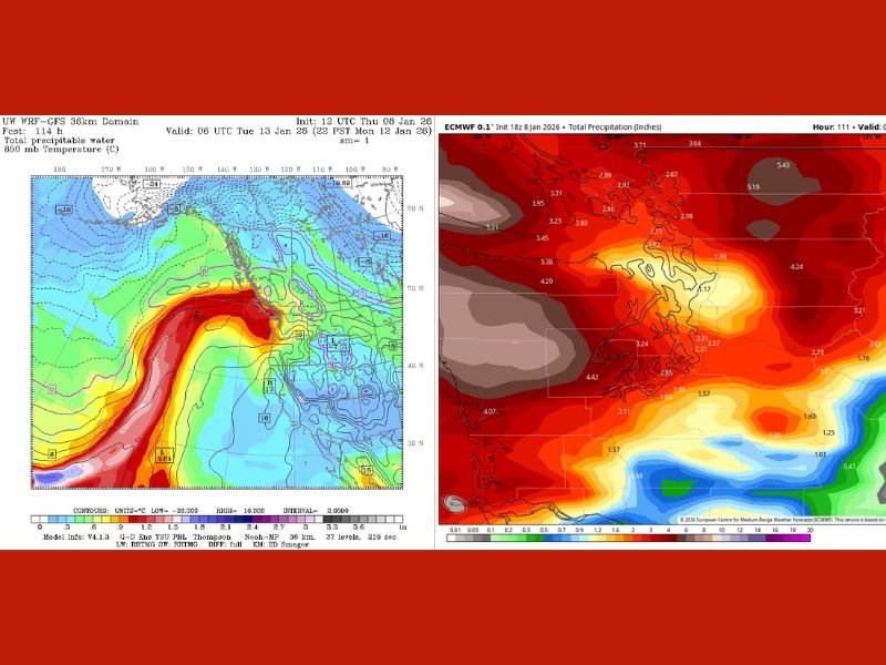
The system is tapping into warm, moisture-rich Pacific air, clearly visible on water vapor and precipitation output. While not as extreme as December’s historic rain event, the incoming storm is expected to deliver widespread steady rain, particularly along the west slopes of the Cascades and coastal ranges.
Rainfall Focus and Snow Level Changes
As the atmospheric river moves inland, snow levels will rise sharply, meaning most precipitation in the mountains will fall as rain rather than snow. This limits additional snowpack gains and increases runoff into rivers and streams.
Model rainfall projections show multiple inches of rain possible across western Washington and northwest Oregon, with the highest totals focused on mountain terrain and wind-favored slopes. Lowland areas will also see prolonged rainfall, though totals will generally be lower than in the higher elevations.
River Levels and Flood Risk Outlook
There remains some uncertainty in exact rainfall totals, but confidence is growing that river responses will be noticeable. Forecasts suggest the Skokomish River could reach moderate flood stage, while several rivers in the central and northern Cascades may approach flood thresholds.
The Snohomish River, as of the latest outlook, is expected to reach “action stage,” roughly 80 percent of flood level, indicating elevated water but not major flooding at this time. Forecasters emphasize that river monitoring will be critical as the event unfolds.
Impacts for Lowlands and Travel
For the lowlands, Sunday is expected to be wet, breezy, and increasingly mild, with rain lingering into Monday. High temperatures are forecast to climb above 50 degrees, reinforcing the rain-heavy pattern rather than winter weather.
While conditions are not currently considered alarming, residents should be prepared for ponding on roads, reduced visibility, and slower travel, especially in areas prone to flooding. Outdoor plans may be affected by persistent rain and blustery conditions.
Pattern Change After the Storm
Once this atmospheric river exits, a significant pattern shift is expected. Extended forecasts show a strong ridge of high pressure building across the entire West Coast, bringing a prolonged dry stretch.
This pattern would favor foggy and frosty nights, with sunny and relatively warm days once fog and inversions break. Forecasters also note that mountain areas could be warmer than the lowlands during this period, a common setup under strong high pressure.
Longer-Range Outlook
Beyond the dry stretch, there are early hints of cooler weather returning in the 10- to 14-day window, though confidence remains low. For now, the focus remains on managing the impacts of one more significant rain event before conditions improve.
Officials continue to monitor river forecasts and will provide updates if flood risks increase. For continued coverage of major weather systems affecting communities across the country, visit NapervilleLocal.com, where we track significant regional and national weather developments that matter.

I’ve lived in Naperville long enough to see how quickly our community changes — from new developments downtown to sudden shifts in our Midwest weather. Reporting on Naperville news and daily forecasts gives me the chance to keep neighbors informed about what really matters. My goal is simple: deliver clear, timely updates so you always know what’s happening in our city and what to expect from the skies above.