
Florida Braces for Sharp Temperature Drop as Cold Front Brings 20s and 30s Wind Chills Monday Morning
FLORIDA — A sharp and sudden weather shift is expected across the Sunshine State as warm weekend conditions give way to a strong cold front Sunday, setting the stage for a polar plunge–style cooldown early Monday morning. Forecast data shows wind chills dropping into the 20s and 30s across large portions of Florida, an unusual level of cold for mid-January.
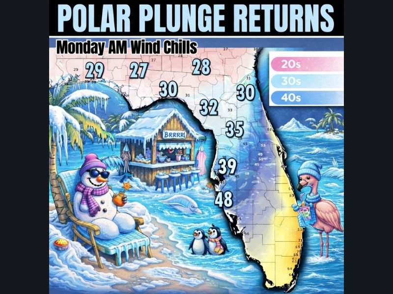
The coldest conditions will be felt Monday morning, when brisk winds combine with falling temperatures. While southern Florida will act as a partial buffer, much of central and northern Florida is expected to experience the coldest wind chills of the season so far.
Warm Weekend Followed by a Rapid Pattern Shift
Florida will start the period on a much warmer note, with above-normal temperatures expected through the weekend. Southerly flow ahead of the front will keep conditions mild, giving residents little indication of the abrupt change ahead.
That changes quickly late Sunday as a strong cold front pushes south, allowing cold continental air to spill into the state. The speed of the front means temperatures will drop rapidly overnight, setting up a much colder start to Monday.
Monday Morning Wind Chills: Who Feels the Coldest Air
Forecast graphics indicate wind chills in the 20s across northern Florida, including the Panhandle and interior north-central regions. Central Florida is projected to see wind chills in the low to mid-30s, especially away from the immediate coast. Along the southern peninsula, conditions will be less extreme, with wind chills mainly in the upper 40s, as warmer air to the south slows the cold air’s progress. This “roadblock” effect limits how far south the coldest air can reach.
Why Wind Chills Will Feel Especially Harsh
The cold air arrival will be accompanied by gusty north winds, which significantly lower how cold temperatures feel on exposed skin. Even where actual air temperatures remain above freezing, wind chills will make conditions feel much colder, particularly during the early morning hours.
This type of setup is especially impactful in Florida, where homes, infrastructure, and residents are less adapted to cold snaps. The sudden change increases the risk of cold-related issues, especially for those outdoors early Monday.
What Residents Should Prepare For
Residents across north and central Florida should plan for cold-sensitive impacts, including the need to protect pets, plants, and exposed plumbing. Those heading out early Monday should dress in layers, as wind will amplify the chill. While a hard freeze is not shown statewide in the available data, the wind chill values alone will feel winter-like, particularly for regions unaccustomed to temperatures in the 20s and 30s.
Cold Snap Expected to Be Brief
The good news is that this cold outbreak is expected to be short-lived. As winds ease and the air mass modifies, temperatures should begin a gradual rebound later in the week.
Still, the Monday morning cold will stand out, especially following a warm weekend, making this one of the sharpest short-term temperature swings Florida has seen this season. For continued coverage of major weather shifts affecting communities across the country, visit NapervilleLocal.com, where we track significant regional and national weather developments that matter.

I’ve lived in Naperville long enough to see how quickly our community changes — from new developments downtown to sudden shifts in our Midwest weather. Reporting on Naperville news and daily forecasts gives me the chance to keep neighbors informed about what really matters. My goal is simple: deliver clear, timely updates so you always know what’s happening in our city and what to expect from the skies above.