
Rare Thundersnow Event Strikes El Paso County as Thunderstorm Produces Snow Across Colorado Springs Area
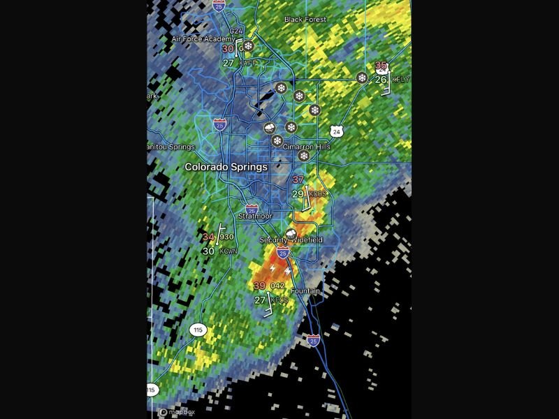
EL PASO COUNTY, COLORADO — A rare weather phenomenon known as thundersnow was observed across El Paso County as a thunderstorm produced snowfall in and around Colorado Springs, catching many residents off guard. Radar data and surface observations showed lightning activity occurring at the same time snow was falling, an unusual combination that only happens under specific atmospheric conditions.
Meteorologists noted that some locations reported temperatures hovering in the upper 20s to mid-30s, allowing precipitation to fall as snow even while thunder and lightning were present. For many in the region, it was the first time witnessing a thunderstorm with snow instead of rain or hail.
What Is Thundersnow and Why It Is Uncommon
Thundersnow occurs when strong atmospheric instability develops within a cold, moisture-rich system, allowing thunderstorms to form even though temperatures are low enough for snow. Unlike typical summer storms, these events are usually short-lived and localized, but can produce brief bursts of heavy snowfall.
Because cold air is generally more stable, the conditions required for thundersnow are rare. This makes such events uncommon in most parts of the United States, including Colorado, where winter storms typically lack the instability needed for lightning.
Radar Data Shows Snow and Lightning Over Colorado Springs
Radar imagery from the event showed bands of moderate to heavy precipitation moving across Colorado Springs, Cimarron Hills, Security-Widefield, and Fountain, with lightning strikes embedded within the snow bands. Several observation sites reported snowfall rates briefly increasing as the storm passed through.
The presence of lightning indicated strong upward motion within the storm, which enhanced snowfall intensity for short periods. While accumulations were not extreme, the combination of snow and thunder made the storm notable.
Why This Event Stood Out to Meteorologists
Forecasters say the storm stood out because it demonstrated how dynamic winter weather can become when cold air interacts with localized instability. Even small changes in temperature and moisture can dramatically alter how precipitation falls.
Events like this are often used as case studies to explain the complexity of winter forecasting, especially along the Front Range, where elevation and terrain can rapidly influence storm behavior.
What Residents Should Know Going Forward
While thundersnow events are rare, they serve as a reminder that winter storms can intensify quickly, even when conditions seem marginal. Sudden bursts of snow can reduce visibility and briefly impact travel, especially during nighttime hours.
Meteorologists emphasize that residents should continue to monitor forecasts closely during winter systems, as unusual combinations of weather can still occur, particularly during transitional seasons and strong storm setups. For continued coverage of rare weather events and significant storm activity across the country, visit NapervilleLocal.com, where we track unusual and impactful weather developments that matter.

I’ve lived in Naperville long enough to see how quickly our community changes — from new developments downtown to sudden shifts in our Midwest weather. Reporting on Naperville news and daily forecasts gives me the chance to keep neighbors informed about what really matters. My goal is simple: deliver clear, timely updates so you always know what’s happening in our city and what to expect from the skies above.