
Cold Front to Dump 1–3 Inches of Rain Across Alabama and Georgia Friday–Saturday, Raising Local Flood Risk in Isolated Areas
ALABAMA AND GEORGIA — A slow-moving cold front is expected to bring widespread heavy rain across Alabama and Georgia from Friday into Saturday, with forecast totals of 1 to 2 inches across much of the region. Meteorologists warn that isolated pockets could receive more than 3 inches, which may be enough to trigger localized flooding, especially in low-lying and poor-drainage areas.
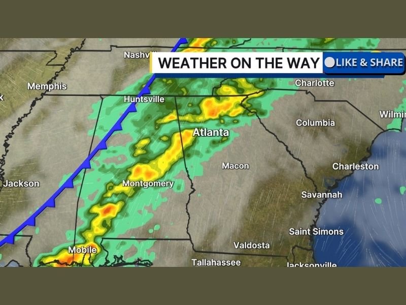
Radar guidance shows a solid band of rain stretching from the Gulf Coast through Montgomery and Atlanta, with embedded thunderstorms developing along the front as it pushes eastward.
Rain Will Be Beneficial, But Local Flooding Is Possible
The incoming rainfall will help ease ongoing drought conditions across parts of Alabama and Georgia. However, forecasters caution that rainfall rates could be heavy at times, particularly where thunderstorms become embedded within the broader rain shield.
Areas that receive multiple rounds of rain in a short time could see ponding on roads, brief urban flooding, and rising creeks, even if widespread river flooding is not expected.
Timing: When the Heaviest Rain Is Expected
Forecast models indicate the rain will begin late Friday, intensify overnight, and continue through much of Saturday as the cold front advances east. Cities along and just ahead of the front — including Mobile, Montgomery, Atlanta, and Huntsville — are likely to see the heaviest rainfall totals. Storm activity should gradually weaken as the system moves toward eastern Georgia later Saturday.
Embedded Storms Could Increase Rainfall Rates
While severe weather is not the primary concern, embedded thunderstorms may briefly enhance rainfall intensity. These storms could produce short bursts of heavy rain, increasing the risk of localized flooding where soils are already saturated. Wind gusts and lightning are also possible near stronger cells, particularly near the Gulf Coast and central Alabama.
What Residents Should Watch For
Residents are advised to monitor weather updates closely and remain alert for:
- Flooded roadways, especially overnight
- Rapid water buildup in urban areas
- Travel slowdowns during periods of heavy rain
Even beneficial rain can become hazardous when it falls too quickly.
For continued coverage of regional weather systems and significant storm impacts across the United States, visit NapervilleLocal.com, where we break down what weather maps actually mean for people on the ground.

I’ve lived in Naperville long enough to see how quickly our community changes — from new developments downtown to sudden shifts in our Midwest weather. Reporting on Naperville news and daily forecasts gives me the chance to keep neighbors informed about what really matters. My goal is simple: deliver clear, timely updates so you always know what’s happening in our city and what to expect from the skies above.