
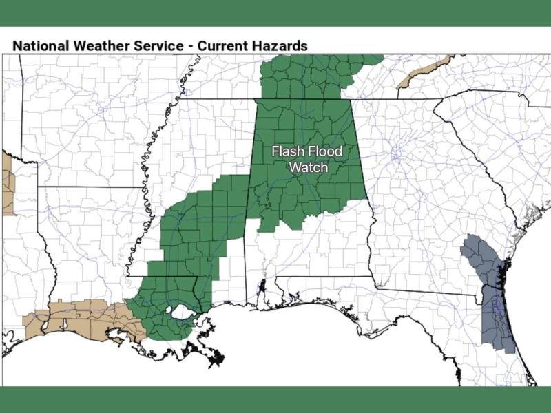
Alabama Faces Flash Flood Watch as 2–4 Inches of Rain and Strong Storms Target the State Through Saturday
ALABAMA — An active weather system moving through the Deep South is set to bring heavy rain, isolated strong storms, and a flash flood risk across Alabama from early Friday through Saturday morning, according to the latest forecasts and National Weather Service hazard maps. The northern half of Alabama is currently under a Flash Flood Watch, where 2 to 4 inches of rain are possible before the system begins to weaken and shift south later Saturday.
Heavy Rain Is the Main Threat Through Saturday Morning
Forecast guidance shows widespread rainfall overspreading Alabama early Friday, with the heaviest totals focused across northern and central portions of the state. Multiple rounds of rain could fall over the same areas, increasing the risk of localized flooding, especially in urban zones, low-lying communities, and areas with poor drainage. By Saturday afternoon, most of the steady rain is expected to shift into southern Alabama, allowing conditions to gradually improve farther north.
Strong Storms Possible, Severe Risk Remains Limited
While a few strong to locally severe thunderstorms cannot be ruled out, forecasters note that a relatively stable air mass should limit widespread severe weather development. If enough instability develops, isolated storms could produce strong wind gusts, mainly during the peak rainfall period.
A brief, isolated tornado is possible, but current data suggests it is not likely and not the primary concern with this system.
Flash Flood Watch Covers Northern Alabama
National Weather Service hazard maps highlight a broad Flash Flood Watch area across northern Alabama, where rainfall rates could briefly overwhelm creeks, streams, and drainage systems. Travel impacts are possible during periods of heavy rain, particularly overnight and during the Friday morning commute. Residents in flood-prone areas are urged to avoid driving through water-covered roads and stay alert for rapidly changing conditions.
Cold Air Arrives After the Storm System Exits
Once the rain clears, much colder air will surge into the Deep South Saturday night into Sunday, accompanied by clearing skies. This will mark a sharp pattern shift, ending the active weather stretch but bringing noticeably cooler conditions to the region.
Temperatures are expected to drop quickly behind the cold front, reinforcing that this system is not just a rainmaker, but a full air-mass change for Alabama and surrounding states. For continued coverage of major U.S. weather systems and clear breakdowns of what forecast maps actually mean, follow updates on NapervilleLocal.com.

I’ve lived in Naperville long enough to see how quickly our community changes — from new developments downtown to sudden shifts in our Midwest weather. Reporting on Naperville news and daily forecasts gives me the chance to keep neighbors informed about what really matters. My goal is simple: deliver clear, timely updates so you always know what’s happening in our city and what to expect from the skies above.