
Alabama Faces Early-Morning Severe Weather Threat as Tornado Risk and Flooding Concerns Increase Across Southern Counties
ALABAMA — A final wave of heavy rain and thunderstorms is moving across the state early Saturday morning, with weather officials warning that severe conditions could intensify over the next several hours, particularly across southern Alabama counties. The most significant threats include damaging wind gusts, localized flooding, and the possibility of a brief tornado. Forecasters say conditions remain dynamic, and residents in affected areas should stay alert through the morning hours.
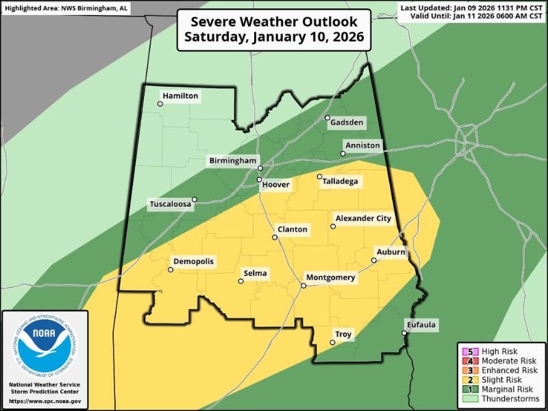
Timing of the Severe Weather Threat
According to the latest First Alert update issued around 3:00 AM, storm coverage is expected to increase before daybreak, with the most active period occurring through the early morning hours. Weather officials note that the severe risk should begin tapering off between 8:00 and 9:00 AM, as the strongest line of storms shifts southeast and exits the region.
Primary Tornado Risk Focused in Southern Alabama
The tornado risk is mainly concentrated south, and a Tornado Watch may be issued for portions of southern Alabama, potentially including several southern counties.
Based on current analysis, the primary area of concern lies along and south of a line stretching from near Demopolis through Jemison, Sylacauga, and Wedowee. Within this zone, atmospheric conditions may briefly support rotating storms capable of producing a short-lived tornado.
Damaging Wind Gusts Possible With Stronger Storms
In addition to the tornado risk, damaging straight-line wind gusts remain a concern with stronger thunderstorms.
These gusts could be strong enough to down tree limbs, damage power lines, and cause isolated power outages, especially where storms become more organized. Even storms that do not reach severe limits may still produce gusty winds capable of causing minor damage.
Flooding Remains the Biggest Overall Concern
While tornado potential exists, officials stress that localized flooding is the most widespread concern.
Repeated rounds of heavy rainfall could lead to ponding on roadways, swollen creeks, and flash flooding, particularly in areas where rain has already fallen or where storms repeatedly track over the same locations. Low-lying areas, poor drainage spots, and urban locations are most vulnerable.
Safety Guidance for Residents in Affected Areas
Residents in southern Alabama are urged to keep weather radios and mobile weather alerts active, especially during the early morning hours when storms may occur while many people are asleep. Officials emphasize the importance of staying informed, monitoring updates closely, and having a plan in place should warnings be issued.
What Happens Next
Meteorologists say they will continue monitoring conditions closely, with continuous updates beginning around 5:00 AM. While there is hope storms remain below severe thresholds, the evolving nature of the system means conditions could still change quickly. Once the stronger line of storms clears the area later this morning, weather conditions are expected to gradually improve.
Southern Alabama faces an early-morning weather threat featuring heavy rain, possible damaging winds, localized flooding, and a low-end tornado risk, particularly south of the Demopolis–Jemison–Sylacauga–Wedowee line. The risk should ease later in the morning, but residents should remain weather-aware until storms move out of the region. For continued weather updates, clear breakdowns of developing threats, and location-based impact reporting, stay connected with NapervilleLocal.com.

I’ve lived in Naperville long enough to see how quickly our community changes — from new developments downtown to sudden shifts in our Midwest weather. Reporting on Naperville news and daily forecasts gives me the chance to keep neighbors informed about what really matters. My goal is simple: deliver clear, timely updates so you always know what’s happening in our city and what to expect from the skies above.