
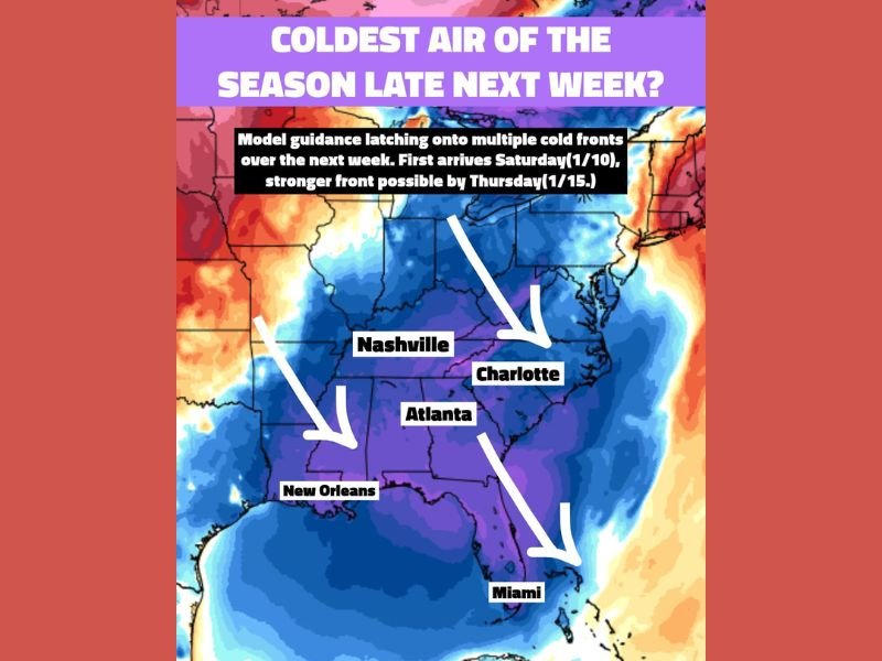
Gulf Coast and Nashville, Atlanta, Charlotte, New Orleans Could See Coldest Air of the Season as Multiple Cold Fronts Target the Region Next Week
GULF COAST & SOUTHEAST UNITED STATES — After an unusually mild late December and early January, weather patterns are shifting sharply as multiple cold fronts are projected to move across the Gulf Coast and Southeast U.S. over the next week, potentially delivering the coldest air of the winter season so far to the region. Forecast models indicate that this colder pattern will unfold in stages, with the first cold front arriving this weekend, followed by a stronger and more impactful surge of cold air by mid to late next week.
First Cold Front Arrives This Weekend
Model guidance shows the initial cold front reaching the region Saturday into Sunday (January 10–11). While this first push will bring a noticeable temperature drop, it is expected to be more of a setup event, introducing cooler air and signaling a broader pattern change.
This front will mark the end of the recent stretch of warmer-than-average conditions and open the door for colder air to move south more efficiently.
Stronger Cold Front Expected Mid to Late Next Week
A secondary and potentially much stronger cold front is projected to arrive around Thursday (January 15). Forecast guidance suggests this front could transport the coldest air of the season into large portions of the Gulf Coast and Southeast U.S. Temperature anomaly maps indicate significantly below-average readings spreading southward, impacting areas from Tennessee and the Carolinas through Georgia, Alabama, Mississippi, Louisiana, and into Florida.
Cities and Regions Likely to Feel the Sharpest Cold
The coldest air mass appears positioned to sweep through major population centers including Nashville, Atlanta, Charlotte, New Orleans, and potentially as far south as Miami. While exact temperature values will continue to adjust as the event approaches, the signal for widespread colder-than-normal conditions is strong. Even South Florida, which typically avoids deeper winter cold, may experience noticeably cooler weather.
Why This Cold Outbreak Matters
This event stands out because it follows a prolonged period of balmy winter weather, increasing the likelihood of a sharp temperature contrast that residents will feel immediately.
Rapid temperature drops can impact travel, outdoor activities, energy usage, and sensitive plants, especially in regions unaccustomed to sustained cold spells. The pattern also raises longer-term questions about whether additional cold air intrusions could follow later in the month.
Forecast Confidence and What to Watch Next
While the timing of the cold fronts is becoming clearer, forecasters caution that specific temperature lows and duration will continue to evolve over the coming days.
Confidence is highest that:
- Multiple cold fronts will occur
- Late next week features the strongest cold
- Much of the Gulf Coast and Southeast will experience colder-than-normal conditions
Details such as freeze potential, overnight lows, and wind impacts will be refined closer to arrival.
The Gulf Coast and Southeast U.S. are entering a much colder weather pattern, with multiple cold fronts next week and a strong chance of the coldest air of the season arriving by mid to late week. Residents across the region should prepare for a noticeable shift away from recent warmth and stay alert for forecast updates as confidence increases. For continued coverage of major weather pattern shifts, regional impact analysis, and clear forecast breakdowns, follow ongoing updates from NapervilleLocal.com.

I’ve lived in Naperville long enough to see how quickly our community changes — from new developments downtown to sudden shifts in our Midwest weather. Reporting on Naperville news and daily forecasts gives me the chance to keep neighbors informed about what really matters. My goal is simple: deliver clear, timely updates so you always know what’s happening in our city and what to expect from the skies above.