
Georgia Winter Weather Outlook Shows Low-Confidence Snow Signal for North Georgia and Atlanta in Mid-January Forecast
Georgia — A new long-range weather forecast is drawing attention across the Southeast after a Global Forecast System (GFS) model run hinted at a possible winter weather setup for North Georgia, including the Atlanta metro area, around January 17–18. Meteorologists stress that the signal remains highly uncertain, but say the timing falls within the region’s most favorable window for winter weather this season.
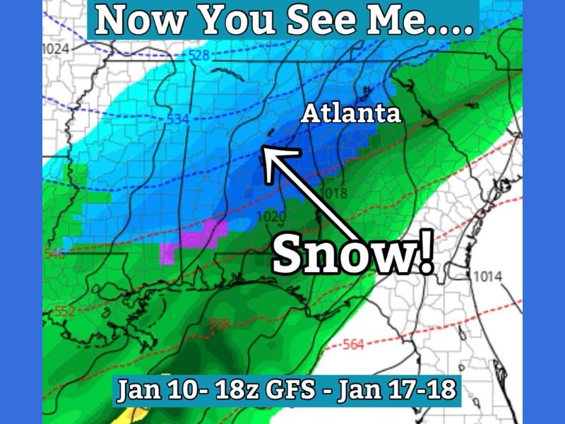
The data comes from the 18z GFS model issued January 10, which shows cold air pushing south while moisture moves across the Southeast. When those two ingredients overlap, the model briefly depicts snow potential across parts of North Georgia. However, experts caution that this is a classic long-range Southern winter scenario that often changes as forecast confidence improves.
What the Latest GFS Model Is Indicating
The model graphic highlights colder air shading over North Georgia, with precipitation stretching across the region. In simple terms, the setup suggests that temperatures could be cold enough for snow if moisture is present at the right time. Atlanta is shown near the transition zone, where outcomes can vary significantly.
Meteorologist Greg Majewski described the scenario as a textbook “now you see it, now you don’t” forecast. At a lead time of seven days, even small shifts in storm track or temperature profiles can eliminate snow chances entirely or replace them with cold rain. Forecasters emphasize that this is not a prediction, but rather an early signal that conditions should be monitored.
Why Forecast Confidence Remains Very Low
Winter weather forecasting in Georgia is particularly challenging due to marginal temperatures. The region often sits near the rain-snow line, meaning a difference of just one or two degrees can change impacts dramatically.
At this range, models frequently:
- Adjust the timing of cold air arrival
- Shift storm tracks east or west
- Reduce or eliminate precipitation altogether
Because of these variables, meteorologists warn against relying on single model images shared online, which can be misleading without proper context.
Why the Next Two Weeks Matter Most for North Georgia
Despite the uncertainty, meteorologists agree that mid to late January is North Georgia’s best opportunity for winter weather. Historically, this period brings stronger cold air intrusions and more favorable jet stream patterns capable of supporting snow.
If North Georgia experiences snow this winter, it is most likely to occur within the next two weeks. That is why forecasters are paying close attention to any developing signals, even those with low confidence.
What Residents Should Know Right Now
There are no watches, warnings, or advisories associated with this forecast. Residents should not make travel plans or preparations based on this early model run.
Instead, weather experts recommend:
- Monitoring trusted local meteorologists
- Waiting for consistency across multiple model runs
- Avoiding hype or assumptions based on long-range graphics
As the forecast window narrows, confidence will either increase or the signal will fade entirely.
The Bottom Line
For now, the potential snow signal for North Georgia remains something to watch, not something to expect. Long-range winter forecasts in the Southeast often change quickly, and many similar setups fail to materialize.
Still, with winter’s most active period underway, the region remains in a position where one well-timed system could bring wintry weather. Updates over the coming days will determine whether this scenario gains traction or disappears. For continued weather coverage and clear, fact-based updates, stay connected with NapervilleLocal.com, where we track developing weather patterns and explain what they mean for communities nationwide.

I’ve lived in Naperville long enough to see how quickly our community changes — from new developments downtown to sudden shifts in our Midwest weather. Reporting on Naperville news and daily forecasts gives me the chance to keep neighbors informed about what really matters. My goal is simple: deliver clear, timely updates so you always know what’s happening in our city and what to expect from the skies above.