
Pennsylvania Snow Showers and Snow Squalls Set to Return Sunday as Cold Front Ends January Thaw
Pennsylvania — After a short-lived January warmup, winter weather is set to return across Pennsylvania on Sunday, with snow showers and potentially dangerous snow squalls expected from Sunday morning into early Monday, according to regional weather analysis. A passing cold front will usher colder air back into the state, increasing the risk for quick-hitting snowfall, reduced visibility, and hazardous travel conditions, especially in western and central parts of Pennsylvania.
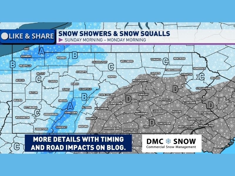
Weather data indicates that the most consistent snow activity will affect northwestern Pennsylvania, the Laurel Highlands, and portions of central Pennsylvania, while eastern and southeastern areas may see lighter impacts or mixed conditions depending on temperatures.
What Is Driving the Return of Snow Across Pennsylvania
The upcoming wintry pattern is being driven by a cold front sweeping eastward across the state, replacing recent mild air with colder January temperatures. As the front passes, bands of snow showers and snow squalls are expected to develop, particularly in areas favored by northwest flow and lake-enhanced moisture.
Unlike large, slow-moving winter storms, snow squalls are brief but intense, often producing sudden bursts of heavy snow, gusty winds, and rapid drops in visibility. These conditions can change road conditions within minutes, even if snowfall totals remain relatively modest.
Areas Most Likely to See Snow Showers and Squalls
Based on the forecast overview, western and north-central Pennsylvania are most likely to experience the greatest impacts. Areas near Erie, Warren, Johnstown, Somerset, and State College may see more persistent snow showers, with additional light accumulations possible, especially at higher elevations.
The Laurel Highlands stand out as a region where colder air and upslope flow could support more frequent snow bursts. Northwestern Pennsylvania may also benefit from lake-enhanced snow, adding to localized totals.
Farther east, including parts of central and southeastern Pennsylvania, snow activity is expected to be more scattered. While snowfall amounts may be lighter, snow squalls remain possible, particularly during peak cold frontal passage.
Timing and Travel Impacts Residents Should Expect
The primary window for snow showers and squalls appears to run from Sunday morning through early Monday morning. During this time, drivers may encounter:
- Sudden whiteout conditions
- Rapidly snow-covered roads
- Sharp drops in visibility with little warning
Even brief snow squalls can be dangerous, especially on highways where traffic speeds remain high. Officials routinely warn that most snow-squall-related accidents occur because drivers are caught off guard, not because of heavy accumulations.
How This Setup Differs From a Major Winter Storm
This event is not expected to be a widespread, high-impact winter storm with heavy totals statewide. Instead, it represents a classic Pennsylvania January pattern, where colder air interacting with moisture produces frequent but uneven snow activity.
While accumulations are generally expected to remain light, the fast-moving and localized nature of snow squalls makes them particularly hazardous. Some locations may see little accumulation, while others experience brief but intense snowfall.
What Pennsylvania Residents Should Do Now
With winter conditions returning, residents are encouraged to prepare for changing road conditions, especially if traveling Sunday or early Monday. Key safety reminders include:
- Slow down immediately when encountering heavy snow
- Turn on headlights to improve visibility
- Avoid sudden braking during squalls
- Monitor local weather updates before travel
Drivers should also be aware that road conditions can improve or worsen quickly as snow bands move through.
Why This Pattern Matters for the Rest of January
This cold front marks a return to more typical January weather after a brief thaw. Meteorologists note that once colder air is reestablished, additional snow chances often follow, particularly in regions prone to lake-effect or upslope snow. While this specific event may not be the season’s biggest, it signals that winter is far from over across Pennsylvania, and similar setups could repeat later in the month.
For continued coverage of developing winter weather, snow safety updates, and regional forecast explanations, stay connected with NapervilleLocal.com, where we track impactful weather patterns and explain what they mean for communities across the country.

I’ve lived in Naperville long enough to see how quickly our community changes — from new developments downtown to sudden shifts in our Midwest weather. Reporting on Naperville news and daily forecasts gives me the chance to keep neighbors informed about what really matters. My goal is simple: deliver clear, timely updates so you always know what’s happening in our city and what to expect from the skies above.