
Developing U.S. Weather Pattern Signals Warm, Dry West and Colder East With Snow Potential Reaching the Gulf Coast States
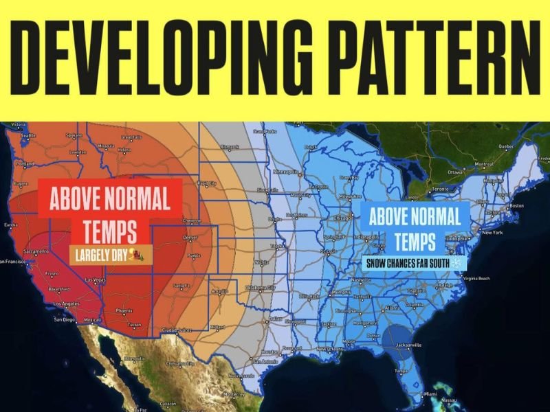
UNITED STATES — Weather models are increasingly aligned on a developing large-scale pattern change that will take shape late this week, persist through the upcoming weekend, and continue into the following week. The emerging setup features a strong temperature divide across the country, with above-normal temperatures dominating the western U.S. while below-normal temperatures settle across much of the eastern half.
This is not a single storm forecast, but rather a broader atmospheric pattern that often serves as a foundation for more impactful winter weather in the East.
Western U.S. Stays Warm and Largely Dry
Across the West Coast, Southwest, and Intermountain West, forecast guidance shows above-average temperatures holding firm. High pressure is expected to remain dominant, keeping conditions mostly dry with limited precipitation opportunities.
States across California, Nevada, Arizona, Utah, and parts of the Rockies are likely to experience a continuation of milder winter conditions, reducing storm chances and reinforcing ongoing dry trends in some areas.
Colder Air Expands Across the Eastern United States
In contrast, the central and eastern U.S. is expected to fall under a colder-than-normal air mass as the pattern locks in. This includes the Midwest, Ohio Valley, Southeast, and East Coast, where temperatures are forecast to trend below seasonal averages.
As colder air pushes southward, the environment becomes increasingly favorable for winter-type precipitation, especially when Gulf moisture is introduced into the system.
Snow Potential Extends Farther South Than Normal
One of the more notable signals in the developing pattern is the potential for snow chances extending as far south as portions of the Gulf Coast states. While exact locations and timing are not yet defined, the setup supports unusually southern snow potential if storm systems align correctly.
This does not guarantee snowfall, but it does indicate a higher-than-normal risk window for winter weather across parts of the Deep South and Southeast as the pattern matures.
Why This Pattern Matters Heading Deeper Into Winter
Patterns like this often act as building blocks for more significant winter systems, especially in January when cold air reservoirs are already established. The sharp west-to-east contrast increases the likelihood of storm development along the boundary zone, particularly across the central and eastern U.S.
Forecasters will be watching closely to see how individual systems interact with this pattern, as timing and placement will ultimately determine impacts.
What Happens Next
Over the next several days, meteorologists will monitor how firmly this pattern locks in and whether embedded storm systems begin to take advantage of the colder eastern setup. Confidence is growing in the overall temperature trend, while specific snowfall details remain premature.
NapervilleLocal.com will continue tracking these national weather signals and explain how evolving patterns across the country could translate into real-world impacts as winter progresses.

I’ve lived in Naperville long enough to see how quickly our community changes — from new developments downtown to sudden shifts in our Midwest weather. Reporting on Naperville news and daily forecasts gives me the chance to keep neighbors informed about what really matters. My goal is simple: deliver clear, timely updates so you always know what’s happening in our city and what to expect from the skies above.