
Georgia Midweek Cold Front Brings Flurries to North Georgia Mountains, With Little to No Snow Accumulation Expected
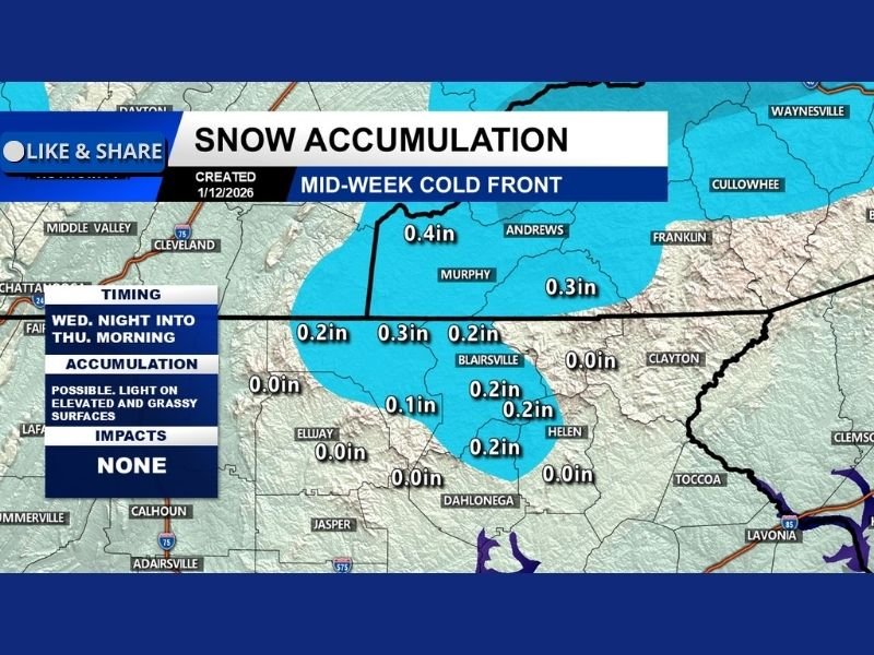
GEORGIA — Forecast confidence is increasing around a midweek cold front moving into Georgia late Wednesday night into early Thursday, and while snow flurries and brief snow showers remain possible across North Georgia, meteorologists say meaningful accumulation is not expected for most areas.
As colder air rushes into the state, precipitation will be too light, too short-lived, and falling on ground temperatures that remain too warm to support widespread snow buildup. The overall message from the latest data is clear: this will not be a significant snow event for Georgia.
Where Light Snow Could Briefly Appear
The only locations with any chance of seeing a light dusting are higher-elevation mountain communities in North Georgia, where colder surface temperatures and elevation may briefly allow snow to stick.
Even in these areas, accumulation is expected to be very minor, generally a dusting on grassy or elevated surfaces, with modeled amounts staying around a few tenths of an inch at most. Valleys, roadways, and lower elevations are expected to see little to no accumulation.
Impacts Expected to Remain Minimal Across the State
Despite social media speculation earlier in the week, forecasters stress that travel impacts are not expected, and no widespread winter weather disruptions are anticipated. Roads should remain largely unaffected, and any snow that does fall should melt quickly after sunrise Thursday. Officials also emphasize that this outcome aligns with earlier guidance, noting that this system was never expected to produce a major snowstorm for Georgia.
Bigger Picture: Cold Air Is the Main Story
While snow chances remain limited, colder air behind the front will be noticeable, especially in North Georgia. Temperatures will drop sharply, reinforcing a winter-like feel across the region even without snow accumulation.
Looking ahead, forecasters note that this may not be the last opportunity for wintry weather, as the broader pattern remains active. However, any future snow chances will depend on better moisture alignment than this system provides. NapervilleLocal.com will continue monitoring national and regional winter weather trends and provide updates as new data becomes available.

Naperville is a community with stories that deserve to be told — both the serious ones about safety and justice, and the lighter ones that capture our culture and daily life. I focus on covering crime reports and court updates while also highlighting the traditions, events, and social trends that shape who we are. Through my reporting, I want to give readers a fuller picture of Naperville — the challenges we face and the character that keeps our city strong.