
Northern Ohio Faces High-Impact Snow Event as Lake-Effect Bands Strengthen Through Thursday Evening
OHIO — A high-impact winter snow event is unfolding across Northern Ohio, with snow beginning Wednesday afternoon and continuing through Thursday evening as storm dynamics strengthen across the region. Forecasters say confidence is high that snowfall totals are increasing, with impacts spreading well beyond the traditional Snowbelt. Overnight short-range model guidance has trended stronger, signaling broader snowfall coverage and more disruptive conditions than earlier forecasts indicated.
Snowfall Coverage Expands Across Northern Ohio
As storm phasing improves, snowfall is no longer expected to be limited to lakeshore counties. Instead, a wider swath of Northern Ohio is now expected to see accumulating snow.
Forecast ranges based on the latest data include:
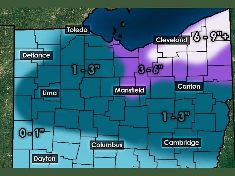
- 6 to 9 inches or more near and east of Cleveland, especially within core lake-effect zones
- 3 to 6 inches across areas from Mansfield toward Canton
- 1 to 3 inches across much of north-central Ohio
- 0 to 1 inch farther south toward Dayton and southern counties
Forecasters note that some of these totals may still be conservative, with high-resolution models suggesting stronger localized snow bands.
Lake-Effect Snow Intensifies Thursday
Snowfall will initially be driven by the larger storm system, but conditions are expected to transition into a more powerful lake-effect setup on Thursday. Persistent snow bands developing off Lake Erie could stall over certain communities, allowing snow to fall continuously for hours. In the most persistent bands, localized totals could exceed a foot, even while nearby areas receive significantly less snow.
Travel Conditions Expected to Deteriorate
With snow becoming heavier and more persistent, travel impacts are expected to worsen, especially Thursday. Anticipated hazards include:
- Snow-covered and slick roadways
- Sudden drops in visibility within heavier snow bands
- Slower commutes and difficult driving conditions
- Increased risk of school delays or closures, particularly in areas receiving 2 to 4 inches or more
Lake-effect snow can intensify rapidly, catching drivers off guard.
Confidence High in the Forecast
Meteorologists say nearly all forecast models are now aligned, reinforcing confidence in a significant snow event. While exact placement of the heaviest bands may still shift, the overall signal for impactful winter weather across Northern Ohio is strong.
Northern Ohio is entering a high-confidence, high-impact winter snow event, with accumulating snow spreading beyond the Snowbelt and lake-effect bands strengthening through Thursday evening. Some communities could see substantial snowfall in a short time, particularly where snow bands persist. Residents are urged to monitor conditions closely, allow extra travel time, and be prepared for rapidly changing weather.

I’ve lived in Naperville long enough to see how quickly our community changes — from new developments downtown to sudden shifts in our Midwest weather. Reporting on Naperville news and daily forecasts gives me the chance to keep neighbors informed about what really matters. My goal is simple: deliver clear, timely updates so you always know what’s happening in our city and what to expect from the skies above.