
Wintry Mix Possible Across Florida and Georgia Coasts Sunday as Coastal Disturbance Tracks East
FLORIDA / GEORGIA — A rare January weather setup is taking shape along the Southeast coastline, with forecast models indicating a coastal disturbance could bring rain mixed with snow or sleet to parts of Florida and South Georgia on Sunday. While confidence in accumulation remains low for now, the signal for wintry precipitation reaching unusually far south is strong enough to draw attention.
The pattern follows a familiar cold-season saying among meteorologists: when January thunder and lightning occur, winter weather often follows days later. That sequence now appears to be unfolding.
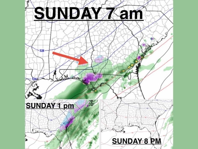
Sunday Morning: Wintry Mix Appears Near the Gulf and Southeast Coast
Forecast maps for Sunday morning show a disturbance lifting eastward from the Gulf region, with wintry mix indicated in purple across parts of northern Florida and southern Georgia. This suggests temperatures in the lower atmosphere may be just cold enough to support snow mixing with rain, particularly during the early hours of the day. The system is expected to ride close to the coastline, where cold air is shallow but still present.
Sunday Afternoon: Precipitation Spreads Along the Georgia Coast
By early Sunday afternoon, precipitation becomes more widespread along the Georgia coast, with rain remaining dominant but embedded pockets of wintry mix possible, especially inland or during heavier bursts.
At this stage:
- Rain is expected to be the primary precipitation type
- Snow or sleet may briefly mix in where colder air holds
- Surface temperatures will be a key factor in determining impacts
Current guidance suggests this phase will be short-lived, with conditions evolving quickly.
Sunday Evening: System Exits the Coast
By Sunday evening, model guidance shows the disturbance moving offshore, with precipitation ending from west to east. As the system pulls away, any wintry mix threat diminishes rapidly, leaving behind cooler but drier conditions.
Accumulation Uncertain, But Pattern Is Notable
At this time, accumulating snow or ice is not guaranteed, and forecasters note that higher-resolution models are still needed to determine whether any measurable accumulation is possible. However, the setup itself is noteworthy, especially with wintry precipitation appearing in Florida for a second consecutive year.
Even without accumulation, seeing snow or sleet mix into rainfall this far south in January is uncommon and climatologically significant.
What Happens Next
Over the next couple of days, meteorologists will monitor:
- Temperature trends near the surface
- Strength and exact track of the coastal disturbance
- Higher-resolution model guidance for accumulation potential
Small changes in timing or temperature could significantly affect outcomes.
A coastal weather system is expected to bring rain and a possible wintry mix to parts of Florida and South Georgia on Sunday, an unusual January scenario for the region. While accumulation remains uncertain, the pattern supports at least a brief window of cold-weather precipitation before the system exits Sunday evening.
Stay tuned for updates as forecast confidence improves, and follow NapervilleLocal.com for continued weather coverage and regional impact updates as this rare setup evolves.

I’ve lived in Naperville long enough to see how quickly our community changes — from new developments downtown to sudden shifts in our Midwest weather. Reporting on Naperville news and daily forecasts gives me the chance to keep neighbors informed about what really matters. My goal is simple: deliver clear, timely updates so you always know what’s happening in our city and what to expect from the skies above.