
Long-Range GFS Model Shows Extreme Snowstorm Scenario Across Midwest and Ohio Valley — But Confidence Is Extremely Low
MIDWEST / OHIO VALLEY — A striking long-range weather model image circulating online is showing a theoretical, high-impact snowstorm across large portions of the Midwest and Ohio Valley, with snowfall totals that would be historic if they ever became reality. However, meteorologists are strongly emphasizing that this scenario is more than 240 hours away and should not be taken seriously at this stage.
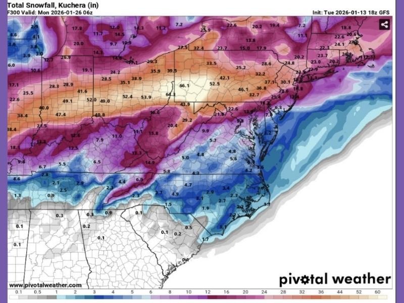
The image comes from an 18z run of the GFS (Global Forecast System), a long-range model known for producing extreme and unrealistic outcomes far in advance.
What the Model Is Showing
The model depiction suggests:
- Widespread heavy snow stretching from the central Midwest into the Ohio Valley
- Snowfall totals in some areas appearing exceptionally high, well beyond normal climatological events
- A large, well-phased storm system that would require near-perfect atmospheric alignment
If such a setup were to verify, it would rank among the most significant winter storms ever observed in the region.
Why This Should Not Be Taken Literally
Despite the dramatic visuals, several factors make this scenario highly unreliable:
- The model run is over 10 days out, well beyond the range where details can be trusted
- Long-range GFS runs frequently show “fantasy storms” that disappear on later updates
- Key ingredients such as storm track, cold air placement, and timing are not yet resolvable
Even the original discussion accompanying the map cautions readers not to worry at all, noting that the output is speculative and not a forecast.
How These Extreme Maps Happen
At long ranges, weather models:
- Struggle to resolve small-scale features that decide rain vs snow
- Over-amplify storm strength due to limited data inputs
- Often display worst-case outcomes that rarely materialize
As the forecast window shortens, these extreme solutions typically weaken, shift, or vanish entirely.
What to Watch Instead
Rather than focusing on a single dramatic image, forecasters will be watching:
- Whether future model runs consistently show a storm signal
- Trends in temperature patterns and jet stream alignment
- Agreement between multiple models, not just one run
Until those signals line up closer to the event window, this remains an interesting but unrealistic long-range scenario.
A long-range GFS model run is showing a hypothetical mega snowstorm across the Midwest and Ohio Valley, but the setup is far too distant and uncertain to be considered a real forecast. These types of images are common in extended model guidance and almost always change dramatically with time.
For accurate winter weather updates, verified forecasts, and clear explanations as conditions evolve, continue following coverage from NapervilleLocal.com, where we focus on clarity, context, and responsible reporting over hype.

I’ve lived in Naperville long enough to see how quickly our community changes — from new developments downtown to sudden shifts in our Midwest weather. Reporting on Naperville news and daily forecasts gives me the chance to keep neighbors informed about what really matters. My goal is simple: deliver clear, timely updates so you always know what’s happening in our city and what to expect from the skies above.