
GFS Continues to Signal Multi-Day Snow Threat Across the Southeast and Mid-Atlantic From Saturday Through Monday
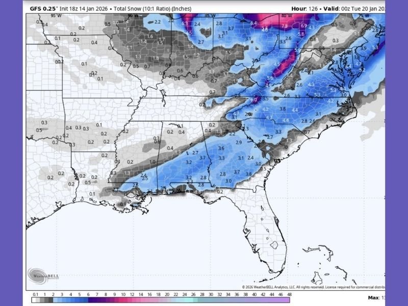
United States — A consistent winter weather signal is continuing to emerge in forecast data as the GFS model once again shows snow dragging across large portions of the Southeast and Mid-Atlantic from Saturday through Monday, repeating the same regional footprint seen in earlier runs.
While the system is not yet finalized, the lack of meaningful change across multiple consecutive model cycles suggests this is no longer a random fluctuation. The persistence of the signal points toward a slow-moving winter setup capable of producing accumulating snow over multiple days, particularly in regions where winter weather is usually brief and fast-moving.
What the Latest GFS Runs Are Showing
The newest GFS snowfall projections continue to outline widespread light to moderate snow totals across parts of Texas, Louisiana, Mississippi, Alabama, Georgia, the Carolinas, Tennessee, and into the Mid-Atlantic, with heavier accumulations farther north.
Key timing signals remain consistent:
- Saturday: Initial snow development as colder air pushes south
- Sunday: Snow coverage expands and intensifies across the same core regions
- Monday: Snow lingers as the system struggles to exit
This repeated timing and placement has now appeared across multiple independent GFS runs, reinforcing the idea that the model is locked onto a similar atmospheric solution.
Why Forecast Confidence Is Gradually Increasing
Forecast uncertainty is normal several days out, but meteorologists tend to take notice when a model keeps returning to the same idea despite routine adjustments. In this case, the GFS has maintained:
- The same snow corridor
- A multi-day duration
- A slow progression rather than a quick exit
While snowfall amounts are still subject to change, the pattern itself has remained stable, which increases confidence that some form of winter weather will impact the region.
This does not guarantee a major storm everywhere, but it does suggest the risk of meaningful winter impacts is rising, especially in areas near the southern edge of the snow shield.
Potential Impacts Across the South and East
If the current forecast trend holds, impacts could include slick roads, travel delays, school disruptions, and scattered power issues, particularly in communities less accustomed to winter weather.
Even modest snow totals can cause significant problems in the South, where road treatment resources are limited and temperatures often hover near freezing. Small shifts in temperature could also introduce mixed precipitation, increasing the risk of icy conditions.
Areas farther north within the Mid-Atlantic and Appalachian regions may see higher snowfall totals, while southern locations remain sensitive to temperature changes that could affect accumulation.
What to Watch as the Forecast Evolves
Although the event window is approaching, key details remain unresolved. Residents in potentially affected areas should:
- Monitor daily forecast updates
- Avoid dismissing the threat based on a single optimistic run
- Prepare for possible Sunday into Monday travel disruptions
- Stay alert for local advisories as confidence increases
This system is not locked, but it is also not fading, and repeated signals suggest winter may not be finished with these regions just yet.
For continued weather coverage, forecast breakdowns, and developing updates, follow ongoing reports from NapervilleLocal.com, where we track major national weather patterns and their broader impacts.

I’ve lived in Naperville long enough to see how quickly our community changes — from new developments downtown to sudden shifts in our Midwest weather. Reporting on Naperville news and daily forecasts gives me the chance to keep neighbors informed about what really matters. My goal is simple: deliver clear, timely updates so you always know what’s happening in our city and what to expect from the skies above.