
Snow Threat Expands Across Louisiana, Mississippi, Alabama, Georgia, Florida, Tennessee, and the Carolinas Late Saturday Into Sunday
United States — Forecast confidence is increasing that snow could reach unusually far south late Saturday into Sunday, as updated model guidance shows a broader and stronger winter signal across large portions of the Deep South and Southeast, including areas not accustomed to seeing snow.
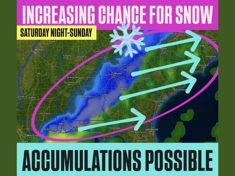
According to the latest trends, snow potential now stretches from Louisiana eastward through Mississippi, Alabama, Georgia, northern Florida, Tennessee, and into the Carolinas, with some models indicating that localized accumulations may be possible if colder air arrives quickly enough.
What the Latest Forecast Trends Show
Recent model runs have continued to trend upward on snow potential, particularly during the Saturday night into Sunday time frame. The data suggests cold air will push farther south while overlapping with sufficient moisture to support snow rather than rain in some locations.
Key signals include:
- Increasing probability of snow across multiple Southern states
- A west-to-east corridor extending from the central Gulf Coast into the Southeast
- Indications that snow may reach parts of Florida, especially north Florida
While confidence on exact snowfall totals remains limited, the geographic extent of the signal is expanding.
Regions Included in the Snow Risk Zone
Based on current guidance, areas with rising snow potential include:
- Louisiana and southern Mississippi
- Central and northern Alabama
- Georgia, including parts of central and northern sections
- Northern Florida, especially inland areas
- Tennessee
- North and South Carolina
Snowfall outcomes will vary significantly by location, elevation, and timing, but even brief snow or light accumulation would be notable for many of these areas.
Why This Setup Is Gaining Attention
Snow events this far south require precise atmospheric alignment, and the current pattern appears to be moving closer to that threshold. Forecast models are increasingly showing:
- Cold air arriving faster and deeper than earlier projections
- Better moisture availability during the coldest period
- A storm track favorable for wintry precipitation
This does not guarantee widespread snow, but it raises the risk enough that forecasters are monitoring the setup closely.
Potential Impacts If Snow Develops
If snow materializes as indicated, impacts could include:
- Slick and hazardous road conditions
- Travel delays, especially overnight and early Sunday
- School or schedule disruptions in areas unfamiliar with snow
- Increased accident risk due to lack of winter road treatment
Even light accumulations can cause outsized impacts across the Deep South and Southeast.
What Residents Should Watch Going Forward
Because this system is still evolving, residents in affected states should:
- Monitor forecast updates through the weekend
- Be cautious with late-night and early-morning travel plans
- Prepare for rapidly changing conditions if temperatures drop faster than expected
Small shifts in temperature or storm timing could significantly alter where snow occurs versus cold rain.
For continued coverage of evolving winter weather threats, forecast trend explanations, and regional impact updates, follow reports from NapervilleLocal.com, where we track major national weather patterns and explain why they matter.

I’ve lived in Naperville long enough to see how quickly our community changes — from new developments downtown to sudden shifts in our Midwest weather. Reporting on Naperville news and daily forecasts gives me the chance to keep neighbors informed about what really matters. My goal is simple: deliver clear, timely updates so you always know what’s happening in our city and what to expect from the skies above.