
Eastern Pacific System Could Funnel Subtropical Moisture Into Mexico and Texas Next Week, Raising Rain Potential
United States — A developing weather system over the Eastern Pacific Ocean is drawing attention as forecast guidance suggests mid- and upper-level moisture could be pulled northward into Mexico and parts of Texas next week, potentially increasing rainfall as a cold front drops into the region.
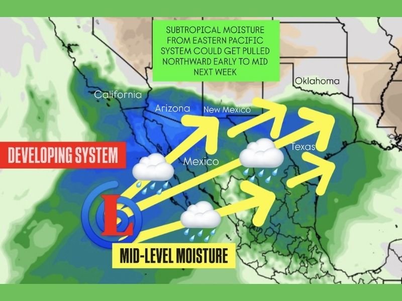
While the setup remains uncertain and is still several days away, meteorologists are monitoring the system closely due to its unusual structure for this time of year and its potential to enhance rain chances across the southern Plains.
What Is Developing in the Eastern Pacific
Satellite and model data indicate a large, agitated area of convection forming over the Eastern Pacific, where warm ocean temperatures and increasing upper-level divergence are creating a favorable environment for cyclogenesis.
Forecast guidance suggests this disturbed area could:
- Become more organized into a defined low-pressure system
- Generate subtropical moisture capable of being drawn northward
- Remain primarily a moisture source rather than a direct land-impacting storm
Some models even briefly hint at tropical or subtropical characteristics, which would be extremely rare for this time of year, though confidence in that outcome remains low.
How Moisture Could Reach Mexico and Texas
As the system develops, an approaching upper-level trough is expected to act as a conveyor, pulling moisture northeastward from the Eastern Pacific.
Current projections show moisture streaming:
- Into western and central Mexico
- Northward toward southern and central Texas
- Possibly brushing far southern portions of the Desert Southwest, though confidence there remains limited
The strongest signal at this time is for Texas, where the moisture could interact with a southward-moving front.
Why Texas Rain Chances Could Increase
Even without a fully tropical system, subtropical moisture alone can significantly enhance rainfall, especially when combined with frontal forcing.
If the current pattern holds, Texas could see:
- Increasing cloud cover
- Periods of moderate to locally heavy rain
- Higher rain totals than would normally be expected from a cold front alone
The timing of the moisture arrival relative to the frontal passage will be a key factor in determining how widespread and impactful rainfall becomes.
What This Does — and Does Not — Mean Right Now
Forecasters stress that this is not a hurricane forecast and not a guaranteed high-impact event. The key takeaway is the potential for moisture enhancement, not storm development over land.
Important points to keep in mind:
- The signal for moisture transport is stronger than the signal for cyclogenesis
- Tropical or subtropical development would be brief, if it occurs at all
- Rain impacts are more likely than wind or severe weather
Confidence will increase as the system becomes better defined over the coming days.
What Residents Should Watch Going Forward
Residents in Mexico and Texas should monitor forecast updates next week, especially if plans depend on dry conditions.
Key things to watch include:
- Updates on the organization of the Eastern Pacific system
- Timing of the approaching cold front
- Rainfall forecasts and any flood-related outlooks
Small changes in timing or storm structure could significantly affect rainfall coverage.
For continued coverage of evolving weather patterns, moisture-driven rain risks, and national forecast trends, follow reports from NapervilleLocal.com, where we track major weather developments across the country and explain why they matter.

I’ve lived in Naperville long enough to see how quickly our community changes — from new developments downtown to sudden shifts in our Midwest weather. Reporting on Naperville news and daily forecasts gives me the chance to keep neighbors informed about what really matters. My goal is simple: deliver clear, timely updates so you always know what’s happening in our city and what to expect from the skies above.