
Georgia, Alabama, South Carolina, and North Carolina See Southward Shift in Snow Axis as NAM Signals 3–6 Inch Potential
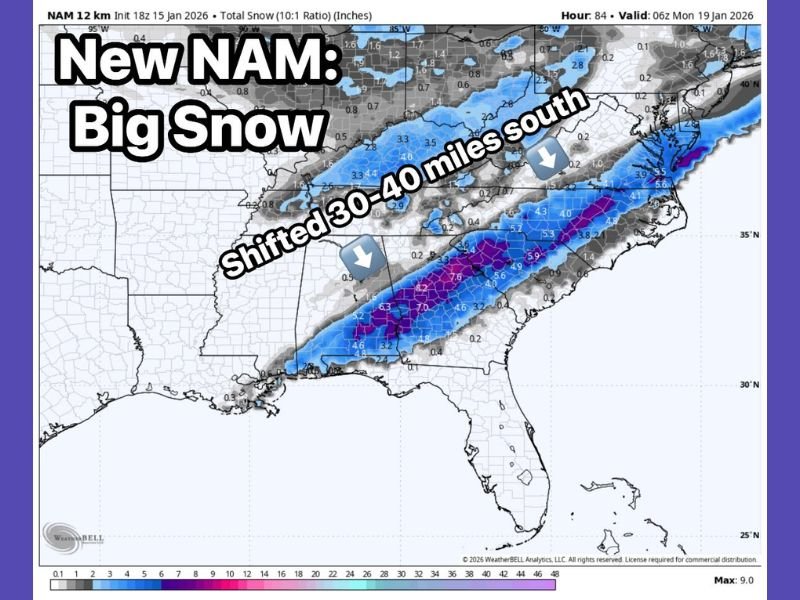
Georgia / South Carolina / North Carolina — A newly updated NAM (North American Mesoscale) forecast model is showing a notable 30 to 40 mile southward shift in the projected snow band, altering which areas could see the greatest impacts as a potential winter weather event approaches.
This adjustment reduces snow potential in the higher elevations while increasing the focus on areas from the I-85 corridor south toward I-20, a trend that more closely aligns with GFS and European model solutions that have consistently favored a farther-south snow axis.
What Changed in the Latest NAM Run
The most significant update in the new NAM guidance is the southward repositioning of the core snow band, which removes the mountains from the center of the heavier snowfall.
Key takeaways from the latest run include:
- 30–40 mile southward shift in the primary snow zone
- Reduced snowfall in mountain regions
- Increasing focus on lower elevations farther south
This shift suggests the storm track may be settling into a solution that places heavier snow closer to major population corridors.
Snow Totals Now Favored Along I-85 and I-20
Despite the southward movement, the NAM still depicts significant snowfall across large portions of the Upstate, with 3 to 6 inches of snow possible from I-85 southward toward I-20.
Under this scenario:
- Parts of northern Georgia, the South Carolina Upstate, and central North Carolina remain at risk
- Snowfall impacts would be more widespread than previously suggested
- Travel disruptions would be more likely in non-mountain locations
Meanwhile, the mountains trend toward much lighter amounts, closer to a dusting in this specific model run.
Why the Southward Trend Matters
Small shifts in storm track can have major consequences in the Southeast, where marginal temperatures and elevation play a critical role in snowfall outcomes.
If future model runs continue this southward trend:
- Heavier impacts would shift into more densely populated areas
- Confidence would increase in accumulating snow outside mountain zones
- Forecast messaging could change quickly
At this stage, forecasters stress that this is still a developing signal, not a final forecast.
What Happens Next
This remains a high-monitoring situation, especially with multiple model suites still refining their solutions. Additional guidance will determine whether the southward trend holds or reverses.
Residents across Georgia, South Carolina, and North Carolina should remain alert for updates, particularly those near I-85 and I-20, where the balance between cold air and moisture will be most critical. NapervilleLocal.com will continue tracking model trends and will provide clear, no-nonsense updates as confidence increases.

I’ve lived in Naperville long enough to see how quickly our community changes — from new developments downtown to sudden shifts in our Midwest weather. Reporting on Naperville news and daily forecasts gives me the chance to keep neighbors informed about what really matters. My goal is simple: deliver clear, timely updates so you always know what’s happening in our city and what to expect from the skies above.