
Florida Panhandle Could See Snowflakes as Cold Air and Moisture Overlap Late Saturday Into Sunday
FLORIDA — Weather models are signaling the potential for a rare winter weather setup across the western Florida Panhandle, where snow or snow flurries could develop late Saturday night into early Sunday if current trends hold. While significant accumulations are not expected, light snow or a dusting cannot be ruled out, especially near the Alabama–Florida border.
Forecast data shows a narrow band of cold air pushing deep into the Southeast, overlapping with just enough moisture to support frozen precipitation. This setup is unusual for Florida, but temperatures are expected to be cold enough to support snow, particularly overnight when surface temperatures are lowest.
What the Latest Model Guidance Shows
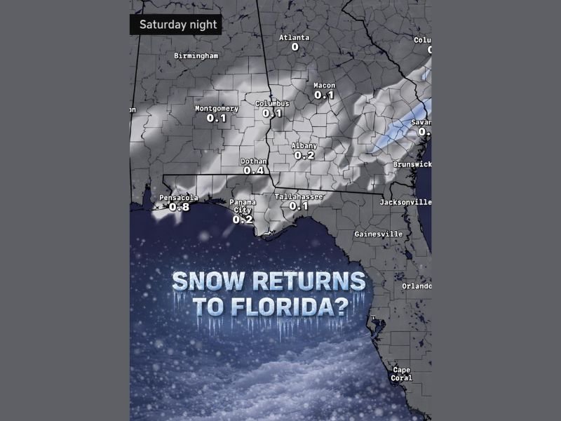
According to the model snapshot, trace to light snowfall amounts are being indicated across parts of southern Alabama, southwest Georgia, and into the western Florida Panhandle:
- Pensacola area: Up to 0.8 inches shown in some model guidance
- Panama City region: Around 0.2 inches
- Tallahassee area: Around 0.1 inches
- Surrounding inland areas show patchy trace amounts
These values suggest light, localized snow, rather than a widespread or impactful winter storm. However, even small amounts can be notable in a region where snow is rare.
Timing: Late Saturday Night Into Sunday Morning
The potential snow window appears to open late Saturday night, continuing into the early hours of Sunday. This timing coincides with the coldest temperatures of the event, increasing the chance that precipitation falls as snow rather than rain.
Meteorologists caution that small shifts in temperature or moisture availability could easily change outcomes. A slight warming trend or reduced moisture would limit snow potential, while colder air holding longer could allow flakes to reach the ground in more areas.
Why Snow in Florida Is Even Being Considered
This setup is driven by a strong southward surge of cold air, allowing freezing temperatures to dip unusually far south. While Florida frequently experiences cold snaps, the overlap of cold air and precipitation is rare, which is why snow events are infrequent and highly sensitive to small forecast changes.
At this point, models show the western Panhandle as the most favorable zone, with snow chances decreasing farther east and south.
What Residents Should Expect
- Snow is possible, not guaranteed
- Any accumulation would likely be light and short-lived
- Bridges and elevated roads could briefly become slick
- Confidence will increase or decrease as models update
Forecast confidence remains moderate to low, and forecasters will be watching closely to see whether this trend holds through Saturday.
Bottom Line
Snowfall in Florida is never common, but current model guidance suggests the western Panhandle has a legitimate chance of seeing snowflakes late Saturday into Sunday. While this does not appear to be a high-impact event, even light snow would be notable for the region.
Residents should stay alert for updated forecasts as the weekend approaches and be prepared for cold temperatures regardless of whether snow ultimately materializes.
Have you ever seen snow where you live in Florida? Share your experience and follow NapervilleLocal.com for continued weather updates across the country.

I’ve lived in Naperville long enough to see how quickly our community changes — from new developments downtown to sudden shifts in our Midwest weather. Reporting on Naperville news and daily forecasts gives me the chance to keep neighbors informed about what really matters. My goal is simple: deliver clear, timely updates so you always know what’s happening in our city and what to expect from the skies above.