
Winter Storm Models Suddenly Shift West After Hurricane Hunter Data, Raising Snow Potential Across the Southeast
SOUTHEASTERN UNITED STATES — Confidence remains low, but an important overnight data update has forced meteorologists to take a closer look at a potential winter weather setup after Hurricane Hunter aircraft sampled the atmosphere around the system and fed that information into the latest model runs.
The result: a noticeable westward shift in the projected snow axis and slightly higher snow probabilities, particularly in parts of the Southeast. While this does not guarantee snow, it represents a meaningful trend change worth watching closely.
Why This Update Matters More Than Earlier Runs
Unlike routine model cycles, this update includes direct atmospheric sampling from Hurricane Hunter aircraft. That real-world data improves how models initialize the storm environment, often leading to sharper and more reliable guidance.
Following the data ingestion:
- Snow signals expanded farther west
- Snow totals increased from near zero to around 1 inch in isolated spots
- Confidence remains low, but trend direction changed
When multiple models respond similarly after improved data, forecasters take notice.
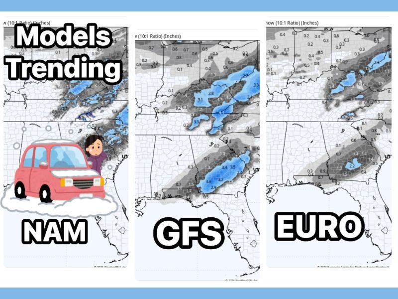
What the Models Are Now Showing
Major guidance suites reacted differently, highlighting the ongoing uncertainty:
- GFS: Introduced light snow totals in portions of the Southeast
- EURO: Also increased snowfall potential, though still limited
- NAM: Continues to suggest localized snow bands depending on storm track
At this stage, impacts remain minor and highly dependent on exact placement, but the shift away from “no snow” scenarios is significant.
A Classic Whiplash Setup Still in Play
This remains a textbook low-confidence, high-volatility winter setup. Small changes in storm track, temperature profiles, or moisture availability could mean:
- Light snow in some areas
- Cold rain in others
- Or little to no impact at all
That uncertainty explains why confidence has been inconsistent across recent forecasts.
What Happens Next
If the westward trend holds through the next round of morning model runs, the signal becomes more meaningful. If it reverses, snow chances will likely diminish again.
Meteorologists will continue monitoring:
- Overnight and morning model cycles
- Thermal profiles near the surface
- Moisture availability as the system develops
Updates will follow as confidence improves.
For ongoing winter weather analysis, forecast updates, and clear explanations of what’s changing — and why — follow NapervilleLocal.com and check back as this evolving situation becomes clearer.

I’ve lived in Naperville long enough to see how quickly our community changes — from new developments downtown to sudden shifts in our Midwest weather. Reporting on Naperville news and daily forecasts gives me the chance to keep neighbors informed about what really matters. My goal is simple: deliver clear, timely updates so you always know what’s happening in our city and what to expect from the skies above.