
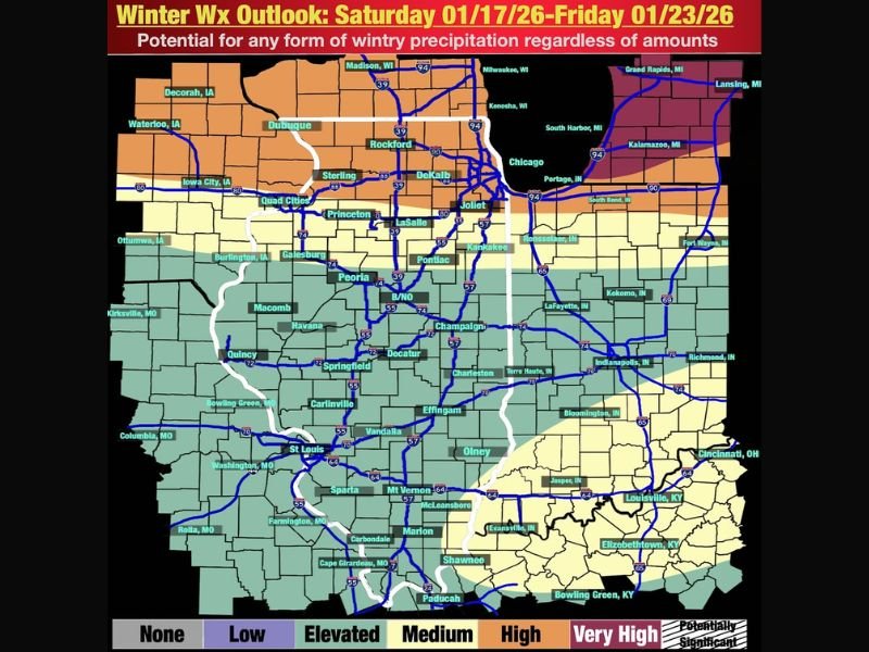
Illinois Enters a Busy Winter Pattern: Multiple Snow Chances Ahead as Clippers and a Midweek System Line Up
ILLINOIS — A colder, more active winter pattern is setting up across the state, opening the door to multiple snow opportunities from Saturday through the middle of next week, even if individual events bring lighter accumulations. Forecast guidance shows repeated systems moving through the region, keeping snow chances in play on several days rather than delivering one major storm.
Saturday Through Tuesday: Clippers Bring Repeated Snow Shower Chances
From Saturday through Tuesday, multiple fast-moving clipper systems are expected to cross the Upper Midwest, producing periodic snow showers across Illinois.
- Northern Illinois has the best chance of seeing snow showers during this period
- Snowfall amounts are expected to stay on the lower side, but
- Snow may fall several times over a short stretch of days
While none of these systems look particularly strong on their own, the repeated nature of the snow showers could still create slick travel at times, especially during early mornings or evenings.
Wednesday Into Thursday: Southern System Adds Snow and Ice Uncertainty
Attention then shifts to midweek, when a southern-stream storm system may move into the region, targeting the southern half of Illinois with a chance for precipitation.
At this stage:
- Forecast confidence is low due to high model variability
- Snow or ice is possible depending on storm track and temperature profiles
- Details will need refinement over the next several days
This system carries higher impact potential than the earlier clippers, but uncertainty remains high.
What This Pattern Means for Illinois
Rather than one dominant winter storm, this setup favors:
- Frequent, lower-end snow chances
- Changing conditions over several days
- Potential travel impacts, even without heavy totals
As colder air locks in, even minor snow events can become disruptive.
Bottom Line
Illinois is entering a busy winter stretch, with snow chances popping up multiple times between now and next Thursday. While accumulations look modest for now, the sheer number of opportunities means winter weather will stay on the radar, especially in northern parts of the state and again midweek farther south.
Residents should stay weather-aware and be prepared for periodic slick conditions, even outside of major storms. For continued Illinois winter weather updates, forecast breakdowns, and local impacts, visit and follow NapervilleLocal.com.

I’ve lived in Naperville long enough to see how quickly our community changes — from new developments downtown to sudden shifts in our Midwest weather. Reporting on Naperville news and daily forecasts gives me the chance to keep neighbors informed about what really matters. My goal is simple: deliver clear, timely updates so you always know what’s happening in our city and what to expect from the skies above.