
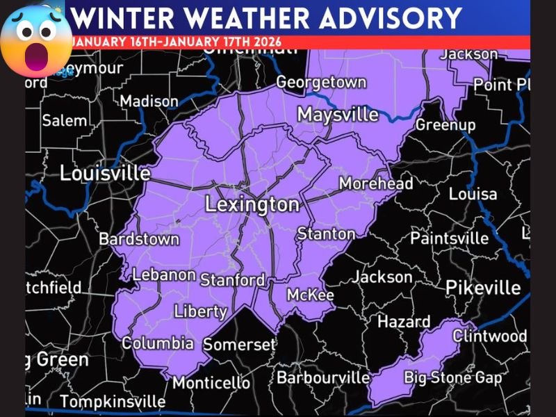
Kentucky Winter Weather Advisory Signals Slushy Snow Switch as Rain Turns to 1–3 Inches With Higher Totals in Elevated Terrain
KENTUCKY — A Winter Weather Advisory has been officially issued for a broad portion of central and eastern Kentucky as a band of rain is expected to sweep through the region and transition to accumulating snow, creating slick travel conditions through late Friday into Saturday. Forecasters say the setup favors widespread light-to-moderate snowfall, with some locations seeing higher totals depending on elevation.
Rain-to-Snow Transition Sets the Stage for Accumulation
According to the advisory, precipitation will begin as rain before changing over to snow as colder air moves in behind the system. Once the transition occurs, snowfall is expected to accumulate efficiently, especially during the colder overnight and early morning hours.
Most locations within the advisory area can expect 1 to 3 inches of snow, enough to impact roads, bridges, and untreated surfaces.
Higher Elevations Could See Locally Heavier Snow
The advisory highlights elevation-driven enhancements, particularly in Letcher and Harlan Counties, where 2 to 4 inches of snow is possible in higher terrain. These areas often cool more quickly and retain colder surface temperatures, allowing snow to accumulate faster than surrounding lowlands.
Travel Impacts Likely Despite Modest Totals
Even though this is not a major winter storm, forecasters caution that slushy accumulations and rapidly changing road conditions are likely, especially during periods when rain flips to snow.
Drivers should be prepared for:
- Reduced visibility during the transition period
- Slick roads as temperatures drop
- Faster accumulation in elevated and rural areas
Bottom Line
This system delivers a classic advisory-level winter setup, with rain changing to snow and enough accumulation to cause travel issues, particularly outside metro areas and at higher elevations. While totals remain manageable, timing and temperature changes will play a key role in impacts. For continued regional winter weather updates, advisories, and pattern changes, stay connected with NapervilleLocal.com.

I’ve lived in Naperville long enough to see how quickly our community changes — from new developments downtown to sudden shifts in our Midwest weather. Reporting on Naperville news and daily forecasts gives me the chance to keep neighbors informed about what really matters. My goal is simple: deliver clear, timely updates so you always know what’s happening in our city and what to expect from the skies above.