
Midwest Winter Is Quietly Overperforming as Ohio Valley Snow Totals Surge 100–300% Above Normal Early in the Season
MIDWEST — A new regional snowfall analysis shows that winter is running well ahead of schedule across a broad swath of the Ohio Valley and Mid-Mississippi Valley, with many areas already reporting near-record percentages of normal seasonal snowfall just halfway through January.
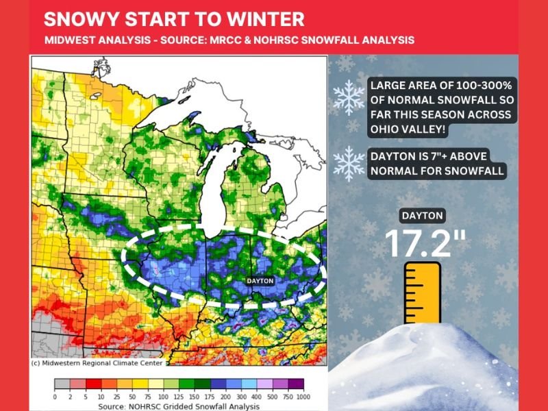
Data compiled from the Midwestern Regional Climate Center (MRCC) and NOHRSC snowfall analysis reveals a pronounced corridor where snowfall totals are right at or significantly above normal, especially from southern Illinois through Indiana and into Ohio.
Ohio Valley Emerging as the Snowfall Sweet Spot
The analysis highlights a large, continuous zone reporting between 100% and 300% of normal snowfall for this point in the season. This indicates not just one or two snow events, but a consistent pattern favoring frequent accumulating snow.
Meteorologists note that farther north, where average snowfall is typically higher, it is normal to see some pockets near or slightly below normal. However, the standout signal this winter is clearly centered farther south than usual, across the heart of the Ohio Valley.
Dayton’s Numbers Show Just How Strong the Trend Is
One of the clearest examples comes from Dayton, Ohio, which has already measured 17.2 inches of snow this season. That places the city more than 7 inches above normal for mid-January. Based on Dayton’s typical seasonal snowfall of around 10 inches by this point, current totals equate to roughly 170% of normal snowfall, with 69% of the entire seasonal average already recorded — and winter still has weeks to go.
What This Pattern Tells Meteorologists
This kind of early-season surplus suggests that storm tracks and cold air placement have been unusually well-aligned across the Midwest so far. Frequent clippers, reinforced cold shots, and efficient snow-producing systems have combined to keep snow chances active without relying on a single major storm.
While this does not guarantee the trend will continue, it does raise the likelihood that additional above-normal snowfall episodes remain possible if the current pattern holds.
The Bottom Line
Winter may not feel extreme every day, but the numbers don’t lie — large portions of the Midwest are quietly stacking snow faster than average, with the Ohio Valley leading the way. If this pattern persists, seasonal snowfall totals could finish well above normal in several key regions. For continued winter pattern tracking, snowfall analysis, and clear Midwest weather breakdowns, stay connected with NapervilleLocal.com and check back as the season unfolds.

I’ve lived in Naperville long enough to see how quickly our community changes — from new developments downtown to sudden shifts in our Midwest weather. Reporting on Naperville news and daily forecasts gives me the chance to keep neighbors informed about what really matters. My goal is simple: deliver clear, timely updates so you always know what’s happening in our city and what to expect from the skies above.