
Kentucky Snow Chances Rising for January 24 as Storm Track Tightens and Winter Setup Grows More Volatile
KENTUCKY — Forecast confidence is increasing that a wintry system could impact Kentucky on Saturday, January 24, but meteorologists caution that the exact storm track remains the deciding factor between a high-impact snow event and a mostly cold rain or mixed scenario. New guidance shows improving agreement among models that accumulating snow is possible across large portions of the state, especially as colder air presses south into the region.
What happens next will depend on small but critical shifts in the storm’s path, a classic winter forecasting challenge in this part of the country.
Why Snow Chances Are Increasing Across Kentucky
Recent model trends show better alignment that a winter system will move through Kentucky this weekend, with Saturday emerging as the most favorable window for snow potential. Multiple guidance solutions now indicate that colder air will be in place early enough to support snow rather than rain in parts of the state.
While this does not guarantee snowfall everywhere, it does mean confidence is rising that wintry precipitation will occur somewhere within Kentucky, rather than missing the region entirely.
Storm Track Will Decide Who Sees Snow, Ice, or Cold Rain
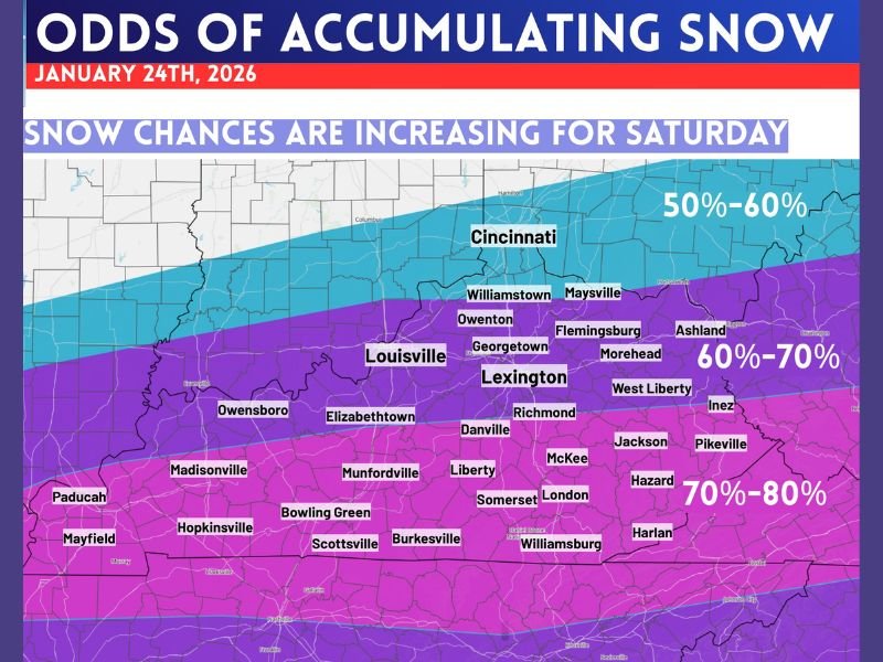
The exact track of the low-pressure system remains the biggest wildcard. In setups like this, a shift of just 30 to 60 miles north or south can dramatically change outcomes.
That track will determine:
- Who receives the best chance for accumulating snow
- Who ends up with a rain/sleet mix
- Who sees mostly cold rain
- How much accumulation actually occurs
This is why forecasters are avoiding county-by-county snowfall maps for now — it is still too early for responsible precision.
What Meteorologists Are Confident In Right Now
There are several points of growing confidence as the event approaches:
- The weekend is the better window for snow potential
- Saturday is the day to watch most closely
- Some parts of Kentucky currently show a better than 80% chance of seeing accumulating snow
- A wintry outcome is becoming more plausible with each model cycle
These signals suggest the setup deserves attention, even if final details are still evolving.
What Remains Uncertain and Why That Matters
Despite stronger signals, exact snowfall amounts are still highly uncertain. The narrow margin between warm and cold air means:
- Snow totals could vary sharply over short distances
- Some locations may overperform while others underperform
- Final outcomes may not be known until closer to the event
This type of setup often produces a razor-thin line between a “big deal” and a “no big deal” outcome, especially across Kentucky’s varied terrain.
The Smart Approach Heading Into the Weekend
Right now, the most responsible forecast strategy is to:
- Watch trends closely
- Track storm-track adjustments
- Keep expectations reasonable
- Avoid locking into specific snowfall totals too early
There is no reason to panic, but there is plenty of reason to stay weather-aware as confidence continues to build.
Bottom Line for Kentucky Residents
This is an increasingly legitimate winter weather setup, but it is not yet a locked-in forecast. Snow chances are rising, confidence is improving, and Saturday appears to be the critical day, but final impacts will depend on last-minute details that are still coming into focus.
As clarity improves, updates will focus on who is most likely to see snow, how much could accumulate, and whether travel impacts become a concern. Stay tuned for continued updates, and share your thoughts or local observations with us at NapervilleLocal.com as this winter system takes shape.

I’ve lived in Naperville long enough to see how quickly our community changes — from new developments downtown to sudden shifts in our Midwest weather. Reporting on Naperville news and daily forecasts gives me the chance to keep neighbors informed about what really matters. My goal is simple: deliver clear, timely updates so you always know what’s happening in our city and what to expect from the skies above.