
Early Model Signals Point to a Potential 6-Inch-Plus Snow Swath Somewhere Across the Central Plains and Midwest Late Week
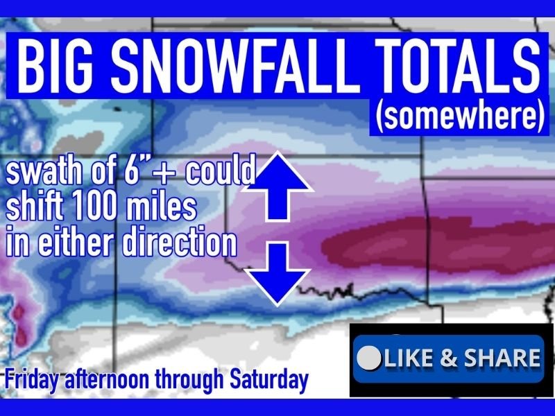
CENTRAL PLAINS & MIDWEST — Snow maps of every shape and size are beginning to circulate, but the most important takeaway right now is this: the pattern supports the possibility of a meaningful snowfall somewhere across the central Plains and Midwest from Friday afternoon through Saturday, even though exact placement is highly uncertain at this early stage.
Latest guidance from the Euro AI model shows a broad zone capable of producing 6 inches or more of snow, with lighter totals surrounding it. This is not a final forecast, but rather an early signal that the atmosphere may be organizing toward a more impactful winter setup.
What the Early Snow Signal Is Showing Right Now
At this range, models are not trying to lock down city-specific totals. Instead, they are highlighting where the overall pattern favors snow development.
Key early takeaways include:
- A solid snow swath capable of 6 inches or more
- Lighter snowfall on the northern and southern edges
- A system developing late Friday and continuing into Saturday
- A broad, regional signal rather than a narrow bullseye
This type of output is best viewed as a starting point, not an end result.
Why the Snow Axis Could Shift Significantly
One of the most important notes in the data is that the core 6-inch-plus snow band could shift as much as 100 miles north or south as the system evolves. That matters because:
- A small change in storm track can dramatically alter who gets heavy snow
- Areas currently under the higher totals could end up with much less
- Locations outside the snow band could still be pulled into heavier totals later
This kind of flexibility is completely normal at this stage of winter forecasting.
Timing Window to Watch Closely
While placement remains uncertain, the timing signal is becoming clearer.
Current guidance suggests:
- Snow developing Friday afternoon
- Peak impacts Friday night into Saturday
- Snow tapering off later Saturday as the system exits
The overall pattern supports a cold enough air mass to sustain snow where the system organizes properly.
What This Is — And What It Is Not
It’s important to clearly define what this information represents.
This IS:
- An early heads-up that a significant snow event is possible somewhere in the region
- A signal worth monitoring closely over the next several days
This is NOT:
- A locked-in snowfall forecast
- A reason to panic or rush into last-minute preparations
- A guarantee of heavy snow at any specific location
How to Think About This Forecast Right Now
The smartest approach at this point is simple:
- Stay aware
- Track how the snow band shifts
- Keep expectations flexible
There is still plenty of time for totals, placement, and impacts to change — and they almost certainly will as the atmosphere fine-tunes the setup.
Bottom Line
Early model guidance suggests a meaningful winter storm is possible somewhere across the central Plains and Midwest late this week, with a potential 6-inch-plus snow swath developing between Friday afternoon and Saturday. However, exact locations remain highly uncertain, and shifts of up to 100 miles are still very much on the table.
This is the calm, early stage of winter forecasting — a time to watch trends, not lock in outcomes. Stay weather-aware, and share what you’re seeing or how you’re preparing by joining the conversation at NapervilleLocal.com as this late-week snow signal continues to evolve.

I’ve lived in Naperville long enough to see how quickly our community changes — from new developments downtown to sudden shifts in our Midwest weather. Reporting on Naperville news and daily forecasts gives me the chance to keep neighbors informed about what really matters. My goal is simple: deliver clear, timely updates so you always know what’s happening in our city and what to expect from the skies above.