
High-Impact Ice Storm Threat Emerges From Texas to the Carolinas as Models Signal Dangerous Late-Week Freeze
SOUTHERN UNITED STATES — A potentially high-impact ice storm is coming into focus from Texas through the Deep South and into the Carolinas, with the most concerning window shaping up for Friday into Saturday. Forecast guidance increasingly supports a setup capable of significant ice accumulation, raising concerns about power outages, infrastructure damage, and major travel disruptions across a large portion of the southern U.S.
While exact totals and placement are still being refined, the overall signal is strong enough to warrant serious attention, especially given how rare and damaging widespread ice storms can be in this region.
Why This Setup Is Especially Dangerous
Ice storms are often more destructive than snowstorms, and this one has several red flags:
- Cold air locked in at the surface
- Moisture overrunning that cold air, favoring freezing rain
- A broad, continuous corridor of ice potential rather than isolated pockets
- Timing that coincides with peak travel and weekend activity
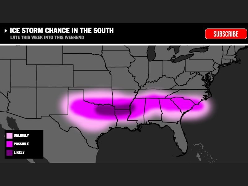
Forecast graphics show a long swath of likely icing stretching from parts of Texas through the lower Mississippi Valley, across the Deep South, and into the Carolinas. Even small changes in temperature or storm track could dramatically increase impacts in specific locations.
Ice Accumulation Could Reach High-Impact Levels
If freezing rain dominates for several hours, ice accretion could become severe. As a reminder:
- ¼ inch of ice can already cause hazardous travel and minor power issues
- ½ inch of ice significantly increases the risk of tree damage and power outages
- ¾ inch or more can result in widespread outages, snapped power lines, and impassable roads
The current pattern supports the possibility of ice amounts that fall into the higher-impact categories, particularly in areas where freezing rain persists the longest.
Potential Impacts Residents Should Prepare For
If this storm evolves as projected, impacts could include:
- Widespread power outages due to ice-loaded trees and power lines
- Downed trees and infrastructure damage
- Extremely dangerous road conditions, including untreated secondary roads
- Extended recovery times, especially in areas not accustomed to ice storms
Travel may become dangerous or impossible in the hardest-hit zones, and even small amounts of ice can make bridges and overpasses treacherous.
Timing and Forecast Uncertainty Still Matter
Although confidence is increasing, this is not yet a locked-in forecast. Ice storms are notoriously sensitive to:
- Surface temperatures
- Depth of cold air
- Exact placement of the warm nose aloft
A shift of 30–50 miles north or south could significantly change who experiences the worst icing. That said, the regional signal is strong, and this is no longer a low-confidence scenario.
Bottom Line
A potentially major ice storm is increasingly likely from Texas to the Carolinas late this week, with Friday and Saturday posing the highest risk. Given the possibility of significant ice accumulation, residents across the southern U.S. should begin monitoring forecasts closely and reviewing winter preparedness plans — especially for power outages and travel disruptions.
There is no need to panic, but this is the stage where early preparation makes a real difference. Stay weather-aware, and join the discussion at NapervilleLocal.com to share how conditions look in your area and what steps you’re taking as this dangerous winter threat comes into sharper focus.

I’ve lived in Naperville long enough to see how quickly our community changes — from new developments downtown to sudden shifts in our Midwest weather. Reporting on Naperville news and daily forecasts gives me the chance to keep neighbors informed about what really matters. My goal is simple: deliver clear, timely updates so you always know what’s happening in our city and what to expect from the skies above.