
Major Winter Storm Signal Strengthens Across Alabama, Tennessee, Mississippi, and Georgia With Snow and Ice Risks January 23–25
ALABAMA — A potentially significant winter storm is increasingly likely to impact a large portion of the Deep South, including Alabama, Tennessee, Mississippi, and Georgia, from Friday through Sunday, January 23–25, as forecast confidence grows in a setup capable of producing heavy snow, freezing rain, sleet, and dangerous travel conditions.
While forecast models still disagree on precise placement, the broader pattern is becoming clearer: cold air will already be in place, and an advancing storm system will interact with that cold air, creating a high-impact winter weather scenario across multiple states.
How the Winter Storm Is Expected to Develop
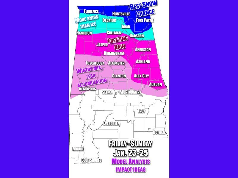
Current projections indicate precipitation will begin Friday night, initially impacting northwest Alabama before spreading eastward and southward through Saturday. As the system strengthens, precipitation type will vary sharply by location, creating a narrow but high-impact transition zone.
Northern areas closer to Tennessee are more likely to see accumulating snow, while portions of central Alabama and northern Georgia face an increasing risk of freezing rain, which historically causes the most severe winter storm damage in the South. Farther south into southern Alabama and Mississippi, a wintry mix is more likely, though impacts could still be significant.
Snow Versus Ice: Why the Storm Track Is Critical
One of the biggest forecast challenges remains the exact storm track, which will determine:
- Who gets the best snow
- Who mixes with sleet or freezing rain
- Where power-threatening ice develops
- How long travel conditions remain hazardous
A shift of just 30–60 miles north or south could completely change outcomes for many communities. In setups like this, the difference between a major winter storm and minimal impacts can be razor-thin.
Areas Showing the Highest Risk Right Now
Based on current model trends:
- Northern Alabama and southern Tennessee show the best signal for accumulating snow
- Central Alabama, including areas from Tuscaloosa through Birmingham to Anniston, remains at elevated risk for freezing rain
- Eastern Mississippi and northern Georgia sit within a transition zone, where snow, sleet, and ice may overlap
These zones will likely shift as models continue refining timing and temperature profiles.
Why Confidence Is Increasing but Details Are Still Uncertain
Multiple forecast models are now showing similar large-scale signals, including entrenched cold air, a strengthening surface low, and sufficient moisture. This agreement increases confidence that a disruptive winter storm is likely, even though exact snow and ice totals cannot yet be responsibly forecast.
This remains a high-impact, low-margin setup, where small changes can lead to large consequences.
What Residents Should Be Doing Now
There is no need to panic, but this is the correct window to begin practical preparation:
- Travel conditions may become dangerous or impossible
- Power outages are possible, especially in ice-prone areas
- Road conditions may deteriorate rapidly, even with light ice
- Cold air behind the system could extend impacts beyond the storm itself
Preparing early carries little downside and significantly reduces risk if the storm intensifies.
Bottom Line
A high-impact winter storm is becoming increasingly likely across Alabama, Tennessee, Mississippi, and Georgia late this week. While exact snowfall and ice totals remain uncertain, the risk of major travel disruptions and infrastructure impacts is real. Confidence will continue to increase as the event approaches.
Stay connected with NapervilleLocal.com for continued updates, forecast refinements, and the latest winter weather alerts as this developing storm becomes clearer.

I’ve lived in Naperville long enough to see how quickly our community changes — from new developments downtown to sudden shifts in our Midwest weather. Reporting on Naperville news and daily forecasts gives me the chance to keep neighbors informed about what really matters. My goal is simple: deliver clear, timely updates so you always know what’s happening in our city and what to expect from the skies above.