
North Georgia Ice Storm Risk Rising as Prolonged Freezing Rain Threatens Travel and Power From Saturday Into Sunday
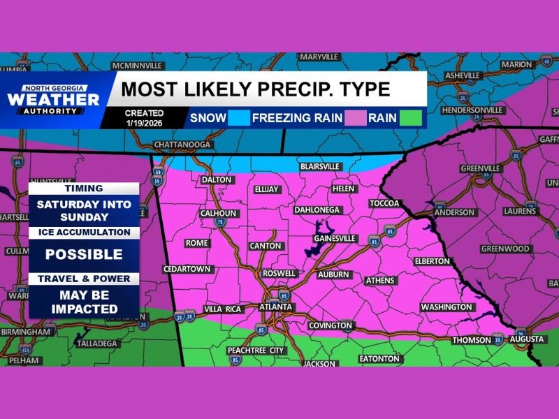
GEORGIA — Growing confidence in new forecast data is raising concern for a potential ice storm across North Georgia this weekend, with conditions increasingly favoring freezing rain rather than snow as cold Arctic air near the surface is overtaken by warmer Gulf moisture aloft. Meteorologists warn this setup could lead to dangerous travel conditions and power disruptions if ice accumulates for an extended period.
Why Freezing Rain Is Becoming the Primary Threat
Forecast analysis shows a shallow but persistent layer of Arctic cold air at the surface, while warmer, moisture-rich air moves overhead. This temperature structure strongly favors freezing rain, not snow, across much of northern Georgia, particularly from Saturday into Sunday.
Instead of snowflakes forming throughout the atmosphere, rain is expected to fall through warm air aloft and freeze instantly on contact with cold roads, bridges, trees, and power lines. This makes even light precipitation high-impact.
Long Duration Raises Ice Accumulation Concerns
One of the most troubling aspects of this setup is how long precipitation may last. Current data suggests 12 to 18 hours of continuous precipitation, giving ice ample time to accumulate.
Key impact thresholds include:
- Less than 0.10 inches of ice can cause hazardous travel
- Around 0.25 inches increases the risk of power outages
- 0.50 inches or more can result in significant infrastructure damage, including downed trees and prolonged power failures
While exact ice totals are still uncertain, the potential for impactful accumulation is clearly present.
Travel and Power Impacts Could Be Widespread
If freezing rain dominates for the duration forecast, roads may become impassable, especially untreated surfaces and elevated roadways. Ice accumulation on trees and power lines could lead to scattered to widespread outages, particularly in areas where freezing rain persists longest.
Officials stress that very little ice is needed to cause major problems, especially in regions not accustomed to frequent ice storms.
What Forecasters Are Watching Next
Meteorologists will continue monitoring:
- The depth and persistence of surface cold air
- Any north or south shift in the warm layer aloft
- Changes in precipitation timing and duration
There is still hope the trend could shift toward less ice, but confidence in an ice-favored setup is increasing, not decreasing, as new data arrives.
Bottom Line
A potential ice storm across North Georgia is becoming more likely, with freezing rain posing a greater threat than snow from Saturday into Sunday. While exact ice amounts are still uncertain, the combination of prolonged precipitation and shallow Arctic cold air raises the risk for dangerous travel and power disruptions.
Residents should stay weather-aware, prepare for possible outages, and avoid unnecessary travel if icing develops.
For continued winter storm updates, forecast changes, and safety guidance, stay connected with NapervilleLocal.com throughout the week.

I’ve lived in Naperville long enough to see how quickly our community changes — from new developments downtown to sudden shifts in our Midwest weather. Reporting on Naperville news and daily forecasts gives me the chance to keep neighbors informed about what really matters. My goal is simple: deliver clear, timely updates so you always know what’s happening in our city and what to expect from the skies above.