
Georgia and Alabama Ice Storm Risk Grows as Models Show Dangerous Ice Accumulation Potential This Weekend
GEORGIA — New rainfall and ice accumulation projections are increasing concern for a potentially dangerous ice storm across Georgia and Alabama this weekend, with model data indicating conditions that could meet or exceed National Weather Service ice storm criteria in parts of the region. While totals will continue to fluctuate, the risk profile is becoming clearer, especially for freezing rain impacts.
Why Ice Accumulation Is the Real Threat
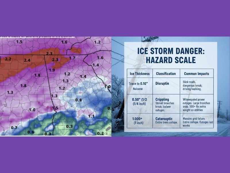
In winter storms, danger is measured by ice thickness, not snowfall. According to the National Weather Service, an Ice Storm Warning is typically issued when ice accretion reaches 0.25 inches or greater. Even lighter glaze amounts can make roads impassable, but quarter-inch ice or more introduces major infrastructure risks.
Unlike snow, ice is far heavier and more destructive, especially when it clings to trees and power lines for extended periods.
How Ice Causes Power Failures and Structural Damage
Ice accumulation affects infrastructure in several dangerous ways:
- Power Line Load: A ½-inch coating of ice can add more than 500 pounds to a single span of power lines between poles.
- Tree Damage: Ice can increase the weight of tree branches by up to 30 times, causing even healthy trees to snap or lean into power lines.
- “Wing Effect” on Wires: Ice often forms a teardrop shape around wires. In strong winds, this acts like an airplane wing, making lines “gallop” until they snap or poles collapse.
- Thawing Hazards: As ice melts, it can fall in heavy chunks. If lower “neutral” wires thaw first, lines may spring upward, touch, and trigger secondary power outages through electrical flashovers.
What Current Projections Suggest
Preliminary projections show significant freezing rain potential, with some model estimates exceeding ½ inch of ice accumulation in parts of the region. While these numbers will change, any storm capable of sustaining freezing rain for many hours dramatically increases the risk of outages and long-lasting impacts.
Forecasters stress that ice storms are deceptive, often appearing manageable early before damage rapidly escalates.
Immediate Safety Guidance if Ice Develops
Residents in potential impact zones should keep the following in mind:
- Treat all downed power lines as live and stay at least 35 feet away
- Avoid parking under trees, even after precipitation ends, as ice-loaded branches can fall hours later
- Check your property’s “drip line”—if trees overhang roofs or driveways, move vehicles and stay clear until ice fully melts
Bottom Line
A dangerous ice storm setup is increasingly possible across Georgia and Alabama, with freezing rain posing a greater threat than snow. While exact totals remain uncertain, the potential for damaging ice accumulation is real, and preparation now could prevent serious safety and power issues later. Stay alert for updates, review your winter safety plan, and follow ongoing coverage at NapervilleLocal.com.

I’ve lived in Naperville long enough to see how quickly our community changes — from new developments downtown to sudden shifts in our Midwest weather. Reporting on Naperville news and daily forecasts gives me the chance to keep neighbors informed about what really matters. My goal is simple: deliver clear, timely updates so you always know what’s happening in our city and what to expect from the skies above.