
Michigan Faces Dangerous Subzero Wind Chills as Arctic Air Tightens Grip Early Tuesday Morning
MICHIGAN — A surge of Arctic air combined with west winds is set to drive dangerously low wind chill values across Michigan early Tuesday morning, January 20, 2026, with several areas experiencing life-threatening cold capable of causing frostbite in minutes, according to the latest regional wind chill analysis.
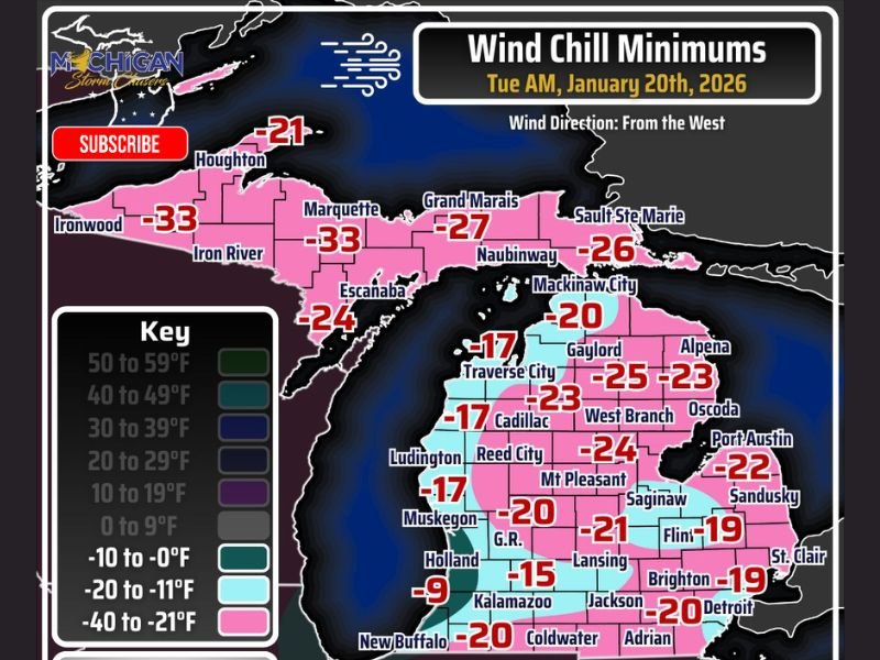
Forecast data shows wind chill readings plunging well below zero statewide, with the most extreme cold focused across the Upper Peninsula and northern Lower Peninsula before daybreak Tuesday.
Wind Chill Values Drop to Life-Threatening Levels Across Michigan
The coldest conditions are expected during the early morning hours, when lingering winds combine with already bitter temperatures. According to the data:
- Upper Peninsula: Wind chills between −26°F and −33°F, including areas near Ironwood, Marquette, and Grand Marais
- Northern Lower Peninsula: Widespread wind chills of −20°F to −25°F, including Gaylord, Cadillac, and West Branch
- Central & Southern Lower Peninsula: Wind chills ranging from −15°F to −21°F, extending through Lansing, Jackson, Flint, and Detroit
Even areas closer to Lake Michigan, where winds briefly weaken overnight, are still expected to see dangerously cold wind chills near or below −10°F.
Why Wind Chill Matters More Than Temperature Alone
While actual air temperatures will fall into the single digits or below, wind is the critical factor increasing danger. Sustained west winds of 5–15 mph, with occasional higher gusts, will rapidly strip heat from exposed skin.
Under these conditions:
- Frostbite can occur in as little as 15–30 minutes
- Hypothermia risk increases quickly, especially for anyone outdoors without proper protection
- Sudden wind gusts can cause rapid drops in perceived temperature, even if winds temporarily ease
Travel and Daily Safety Concerns
Although snowfall is not the primary issue, extreme cold alone can create hazards, especially for early-morning travel.
Drivers should be aware of:
- Reduced vehicle reliability due to cold-related mechanical stress
- Increased risk if stranded, even briefly
- Slower emergency response times in remote or rural areas
Schools and municipalities often use wind chill thresholds near −20°F when evaluating closures or delays, meaning some areas may approach critical decision points.
Cold Safety Tips for Michigan Residents
Officials strongly recommend taking precautions ahead of Tuesday morning:
- Limit outdoor exposure during early morning hours
- Dress in layers, covering hands, face, and ears
- Keep emergency supplies in vehicles, including blankets and gloves
- Check on vulnerable individuals, including elderly neighbors and those without reliable heating
Even short outdoor tasks can become dangerous when wind chills drop into the −20s and −30s.
What Happens Next
Conditions are expected to gradually improve later Tuesday as winds ease and temperatures slowly recover, but dangerous cold will linger into the morning commute across much of Michigan.
Residents are urged to remain alert and take the cold seriously — this is not routine winter weather, even by Michigan standards.
Have you experienced extreme cold like this before, or are you taking extra precautions this week? Share your thoughts and stay updated with the latest weather coverage on NapervilleLocal.com.

I’ve lived in Naperville long enough to see how quickly our community changes — from new developments downtown to sudden shifts in our Midwest weather. Reporting on Naperville news and daily forecasts gives me the chance to keep neighbors informed about what really matters. My goal is simple: deliver clear, timely updates so you always know what’s happening in our city and what to expect from the skies above.