
Texas Braces for a Dangerous Friday Night Ice Storm as Freezing Rain Locks In and Roads Turn Hazardous
TEXAS — Short-range forecast guidance is increasingly confident that North Texas will be hit by a high-impact winter storm Friday night, driven by widespread freezing rain and sleet that is expected to rapidly coat roads, bridges, power lines, and trees. Meteorologists warn this could become a paralyzing ice event, especially across the Dallas–Fort Worth metro and surrounding counties.
Friday Night Timeline: How the Ice Storm Unfolds
Forecast data shows conditions deteriorating quickly Friday afternoon and evening:
- Winter Storm Watch begins around 12 PM Friday
- Travel impacts begin by roughly 2 PM, first in northern counties
- Peak impacts from 4 PM to 8 PM across the heart of the metro area
- All locations drop to freezing by around 9 PM Friday night
- Temperatures fall below 28°F near midnight, allowing ice to stick aggressively to all surfaces
Once temperatures fall to 28°F or lower, freezing rain becomes far more dangerous, as ice accumulates faster and does not melt between precipitation bursts.
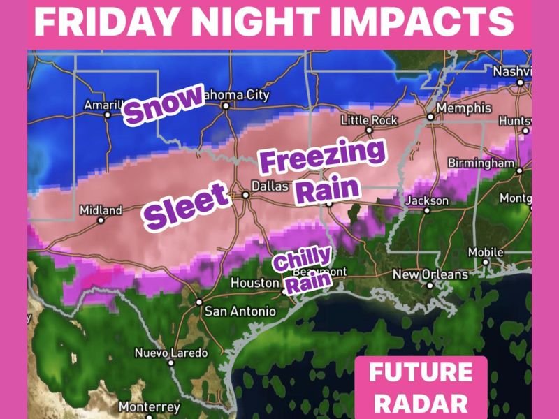
Freezing Rain Dominates, With Sleet and Snow Mixing In
The future radar projection shows a classic ice-storm setup:
- Freezing rain is the dominant precipitation type across North and Central Texas
- Sleet mixes in from west to east, especially near the freezing line
- Snow remains farther north, mainly outside Texas
- Cold rain continues south toward the Gulf Coast, including Houston and coastal areas
This setup is particularly dangerous because liquid rain continues falling onto sub-freezing surfaces, rapidly glazing roads and elevated structures.
Saturday Conditions Remain Hazardous
Conditions do not improve quickly once the storm begins:
- Saturday morning temperatures near 20°F
- Freezing rain and sleet continue into Saturday
- A slow transition to snow is possible later Saturday in some areas
- Roads may remain impassable for extended periods, even after precipitation tapers
With ice already in place, any additional precipitation worsens travel and power risks.
Why This Storm Is Especially Dangerous
Ice storms are often more destructive than snowstorms, and this setup checks several red-flag boxes:
- Freezing rain lasting for hours
- Sub-28°F temperatures, which lock ice in place
- High likelihood of road shutdowns
- Potential power outages due to ice-laden power lines and falling tree limbs
Meteorologists strongly advise residents to plan on staying home for at least a couple of days if possible.
Safety and Preparation Guidance
Residents across North Texas should prepare now:
- Avoid all unnecessary travel starting Friday afternoon
- Complete errands early Friday
- Charge devices and prepare for possible power outages
- Do not drive on icy roads, even if they appear merely wet
Once freezing rain begins, conditions can deteriorate faster than road crews can respond.
What to Watch Going Forward
Forecast confidence is high that Friday night into Saturday will be the most dangerous window, though exact precipitation types and amounts may still shift slightly. Even small changes in temperature can determine whether an area sees sleet, ice, or snow — but freezing rain remains the primary threat.
This is shaping up to be a serious Texas ice storm, not a routine winter inconvenience.
Are you preparing for this Texas ice storm, or adjusting travel plans for Friday night and Saturday? Share your thoughts and stay informed with continued weather coverage on NapervilleLocal.com.

I’ve lived in Naperville long enough to see how quickly our community changes — from new developments downtown to sudden shifts in our Midwest weather. Reporting on Naperville news and daily forecasts gives me the chance to keep neighbors informed about what really matters. My goal is simple: deliver clear, timely updates so you always know what’s happening in our city and what to expect from the skies above.