
Texas, Oklahoma, Arkansas, Louisiana, Mississippi, Tennessee, Alabama, Georgia, and North Carolina Face Potentially Crippling Ice Storm With Historic Accumulations January 24–26
TEXAS – A rapidly evolving winter storm setup is raising serious concern for a widespread and potentially crippling ice storm across large portions of the Southern Plains and Deep South late this week into the weekend. Forecast language from the National Weather Service (NWS) is intensifying, with officials warning this system could produce historic ice accumulations capable of causing long-duration power outages, dangerous travel conditions, and infrastructure damage.
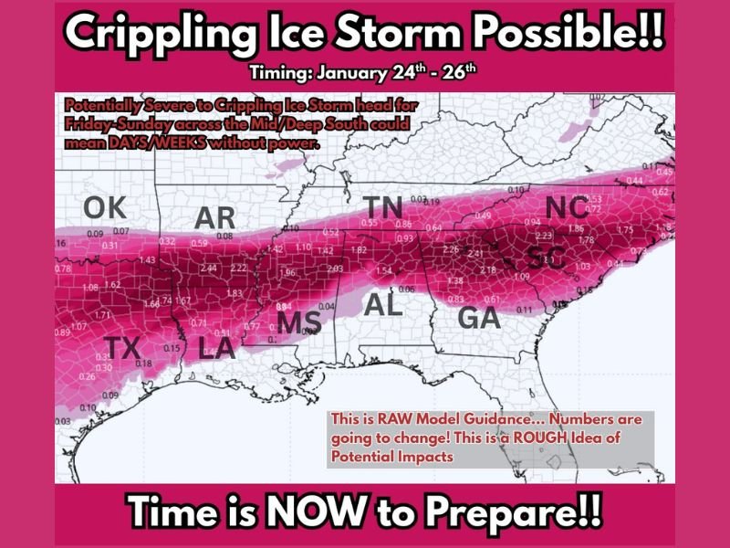
Storm Timing and Regional Focus
Current model guidance places the highest-impact window from Friday through Sunday, January 24–26. The core threat zone stretches from north and central Texas through southern Oklahoma and Arkansas, continuing east across Louisiana, Mississippi, Alabama, Tennessee, Georgia, and into North Carolina.
Forecast confidence is increasing that freezing rain will dominate, rather than snow, which dramatically raises the risk level.
Why This Ice Storm Is Especially Dangerous
Ice storms are far more destructive than snow events, and even small accumulations can cause major impacts.
Key concerns include:
- Less than 0.10 inches of ice can make roads nearly impassable
- 0.25 inches or more meets the NWS definition of an official ice storm
- 0.50 inches can add over 500 pounds of weight to power lines
- Tree limbs may increase in weight by up to 30 times, leading to widespread failures
- Wind interacting with ice-coated power lines can cause line galloping, snapping lines and poles
The model guidance shown represents a rough, early estimate, but the signal for widespread damaging ice is clear.
Power Outages Could Last Days or Longer
If current trends hold, parts of the Mid and Deep South could experience multi-day or even multi-week power outages. Ice accumulation combined with cold temperatures would significantly slow restoration efforts, particularly in rural areas and heavily wooded regions.
Residents should plan as if power may not be available for an extended period.
Preparation Is Critical — What To Do Now
Officials stress that now is the time to prepare, not after impacts begin.
Before the Storm Arrives
- Charge all devices: phones, battery packs, flashlights
- Use flame-free lighting: flashlights over candles
- Stock food and water for at least 2–3 days, focusing on no-cook options
- Gather warm layers: blankets, hats, gloves — homes lose heat quickly
- Fuel vehicles early: gas stations may lose power
Around the Home
- Trim weak branches near your house if time allows
- Seal drafts using towels at doors and windows
- Protect pipes by letting faucets drip and opening cabinet doors
- Never use grills or generators indoors due to carbon monoxide risk
Forecast Confidence Will Continue to Improve
Meteorologists emphasize that specific ice totals will change, but the overall risk signal is not going away. The setup strongly supports a long-duration freezing rain event, which historically leads to the most severe winter impacts in the South.
Residents across Texas, Oklahoma, Arkansas, Louisiana, Mississippi, Tennessee, Alabama, Georgia, and North Carolina should stay alert for updated watches and warnings as this storm approaches.
Are you preparing for potential power outages and dangerous travel conditions where you live? Share your thoughts and stay updated with ongoing weather coverage on NapervilleLocal.com.

I’ve lived in Naperville long enough to see how quickly our community changes — from new developments downtown to sudden shifts in our Midwest weather. Reporting on Naperville news and daily forecasts gives me the chance to keep neighbors informed about what really matters. My goal is simple: deliver clear, timely updates so you always know what’s happening in our city and what to expect from the skies above.