
Near-Blizzard Conditions Possible Across Oklahoma Early Saturday as Strong Winds and Blowing Snow Intensify
OKLAHOMA — High-resolution forecast data is signaling a high-impact winter weather scenario early Saturday morning, with parts of central and eastern Oklahoma potentially experiencing near-blizzard conditions as strong winds combine with falling and blowing snow. While official blizzard criteria may fall just short, meteorologists warn that conditions could be dangerously close, especially during the early morning hours.
What Defines Blizzard Conditions — And How Close This Comes
A blizzard is defined by the following criteria:
- Sustained winds or frequent gusts of 35 mph or higher
- Considerable falling and/or blowing snow
- Visibility reduced to ¼ mile or less
- Conditions lasting at least 3 hours
Forecast guidance shows wind speeds approaching these thresholds, meaning blowing snow and sharply reduced visibility are a real concern even if wind gusts remain just under official criteria.
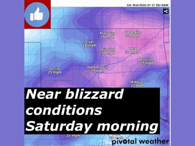
Strong Winds Expected Across Much of Oklahoma
Wind projections for early Saturday morning show widespread gusts between 25 and 32 mph, with locally higher gusts possible:
- Bartlesville: ~32 mph
- Tulsa: ~31 mph
- Stillwater: ~30 mph
- Oklahoma City: ~29 mph
- Ponca City: ~29 mph
- Muskogee: ~27 mph
These winds are strong enough to blow and drift snow, especially in open areas and along highways.
Blowing Snow Could Severely Reduce Visibility
Even moderate snowfall can become dangerous under these wind speeds. Forecast models indicate that blowing snow may significantly reduce visibility, creating whiteout-like conditions at times, particularly during heavier snow bursts.
Travel during the early Saturday morning window could become hazardous very quickly, especially on east-west roads exposed to strong north or northwest winds.
Why Travel Conditions Could Deteriorate Fast
Meteorologists caution that:
- Snow may already be on the ground when winds increase
- Strong gusts can rapidly erase road visibility
- Conditions may meet near-blizzard thresholds intermittently
Even without a formal blizzard warning, impacts could feel blizzard-like for drivers.
Key Takeaways for Residents and Travelers
- Near-blizzard conditions are possible early Saturday
- Strong winds and blowing snow are the main hazards
- Visibility reductions could be sudden and severe
- Travel is strongly discouraged during peak impact hours
Residents are urged to closely monitor updates, finalize preparations early, and avoid unnecessary travel until conditions improve. Stay weather-aware and follow the latest updates at NapervilleLocal.com.

I’ve lived in Naperville long enough to see how quickly our community changes — from new developments downtown to sudden shifts in our Midwest weather. Reporting on Naperville news and daily forecasts gives me the chance to keep neighbors informed about what really matters. My goal is simple: deliver clear, timely updates so you always know what’s happening in our city and what to expect from the skies above.