
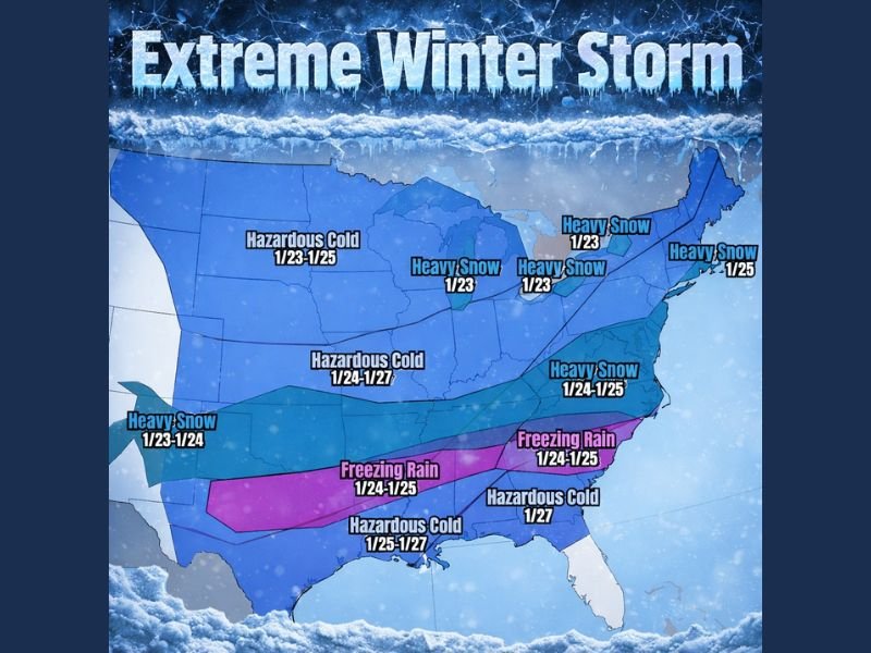
Major Winter Storm Threatens Texas, Oklahoma, Arkansas, Tennessee, Alabama, Georgia, North Carolina, and Great Lakes States With Snow, Ice, and Arctic Cold
UNITED STATES — Confidence continues to rise that a high-impact winter storm will affect a large portion of the central and eastern United States, beginning Friday and intensifying through the weekend, according to the latest National Weather Service guidance. Forecast data points to a dangerous combination of heavy snow, significant ice accumulation, and expanding Arctic cold, with impacts stretching from the Southern Plains into the Great Lakes and Northeast.
Heavy Snow Expands From the Plains Into the Midwest and Great Lakes
Forecast guidance shows a broad swath of heavy snowfall developing across the central U.S. before spreading east. Snow is expected to begin across parts of Texas, Oklahoma, and Arkansas late Friday, then intensify as the system moves toward the Midwest and Great Lakes.
By Saturday, Illinois, Michigan, Ohio, and surrounding states are likely to see accumulating snow, with some areas facing prolonged snowfall lasting multiple days. The storm’s slow eastward progression increases the risk for double-digit snow totals, particularly where colder air remains locked in place.
Ice Storm Risk Increases Across the Deep South and Southeast
South of the heavy snow band, freezing rain is expected to become a major concern, especially across portions of the Southern Plains, Deep South, and Southeast. Forecast maps highlight a corridor of potential ice accumulation affecting Texas, Arkansas, Mississippi, Alabama, Georgia, and North Carolina.
Key concerns include:
- Freezing rain developing January 24–25
- Ice accumulation capable of damaging trees and power lines
- Extended power outage risk where ice and wind overlap
This ice zone is especially dangerous because cold air will linger, preventing rapid melting.
Arctic Cold Spreads South and Lingers Into Next Week
Behind the storm system, Arctic air is forecast to surge southward, reinforcing hazardous conditions across much of the country. Temperatures are expected to fall well below seasonal averages, prolonging snow and ice impacts and making travel recovery difficult.
Forecast highlights include:
- Hazardous cold across the Plains, Midwest, and Great Lakes
- Cold air pushing into the Southeast and Gulf Coast
- Unusually cold conditions reaching parts of Florida early next week
The persistence of this cold air raises concerns for infrastructure strain, frozen pipes, and extended travel disruptions.
Storm Timing and Evolution
While exact snowfall and ice totals are still being refined, the overall timeline remains consistent:
- Friday: Snow and ice begin developing across the Southern Plains
- Saturday–Sunday: Storm intensifies and spreads east into the Midwest, Southeast, and Great Lakes
- Early Next Week: Arctic cold dominates much of the eastern U.S.
Meteorologists stress that small shifts in storm track could significantly change local impacts, especially along the snow–ice boundary.
Why Forecasters Are Watching This Storm Closely
This system stands out due to its large geographic footprint, multi-day duration, and the overlap of snow, ice, and extreme cold. Even if final totals shift, the potential for widespread disruption remains high, particularly in regions not accustomed to prolonged winter weather.
Stay informed with continued forecasts and impact updates at NapervilleLocal.com as this major winter storm continues to develop.

I’ve lived in Naperville long enough to see how quickly our community changes — from new developments downtown to sudden shifts in our Midwest weather. Reporting on Naperville news and daily forecasts gives me the chance to keep neighbors informed about what really matters. My goal is simple: deliver clear, timely updates so you always know what’s happening in our city and what to expect from the skies above.