
Historic Ice Storm Threat Builds Across Texas, Louisiana, Mississippi, Alabama, Georgia, North Carolina, and Virginia With Catastrophic Impacts Possible This Weekend
UNITED STATES — Confidence is increasing that a rare and potentially historic ice storm is setting up across a wide portion of the southern and southeastern United States this weekend. Forecast models are now consistently showing widespread freezing rain totals between 1 and 2 inches, with some localized areas potentially exceeding that threshold — a level that meteorologists classify as catastrophic.
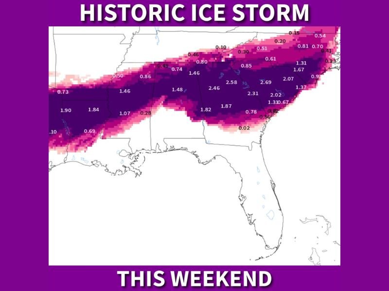
Why This Ice Storm Is Being Labeled Historic
Ice accumulation does not need to be extreme to cause major damage, but the values shown in the latest guidance are well beyond typical winter events for the South. For context, just 0.50 inches of ice is enough to cause widespread tree damage and power failures. Current projections showing 1–2+ inches place this event in a category rarely seen since major historical storms, including the February 1994 Great Southern Ice Storm.
The model depiction shows a long, continuous corridor of severe icing stretching from north and east Texas through Louisiana, Mississippi, Alabama, Georgia, and into North Carolina and Virginia. This type of alignment significantly raises the risk of multi-day infrastructure failures.
Core Impact Zone Based on Current Guidance
While small track shifts are still possible, the highest confidence zone for destructive icing currently includes:
- Texas (especially north and northeast Texas)
- Louisiana
- Mississippi
- Alabama
- Georgia
- North Carolina
- Virginia
The most severe impacts are expected to remain north of the Gulf Coast, but icing as far south as Interstate 10 in Texas and western Louisiana remains possible.
What Residents Should Expect If This Scenario Verifies
An ice storm of this magnitude would produce far more damage than snow, particularly in regions with dense tree canopies and above-ground power infrastructure. Tree limbs coated in thick ice become unstable, and once they begin failing, power lines often follow.
Potential impacts include:
- Widespread and prolonged power outages
- Downed trees blocking roadways
- Crippled travel along major corridors, including I-20
- Flight cancellations lasting several days
- Dangerous conditions for emergency response
Travel north or through the affected corridor could become nearly impossible for an extended period, especially once icing begins.
Why Preparation Is Being Urged Early
Meteorologists are stressing preparation because once freezing rain begins, conditions deteriorate quickly and recovery becomes difficult. Power restoration following major ice storms often takes days to weeks, not hours.
Residents in the path are being advised to prepare similarly to a hurricane scenario:
- Secure non-perishable food and water
- Charge all phones, battery packs, and flashlights
- Protect pipes, pets, plants, and people
- Fuel vehicles early
- Trim vulnerable tree limbs near homes if time allows
- Prepare for extended cold if power is lost
Bottom Line
Even though exact placement will continue to be refined, the signal for a major, high-impact ice storm is strong and persistent. Where the worst icing ultimately sets up, impacts could be severe, long-lasting, and disruptive on a regional scale.
NapervilleLocal.com will continue closely tracking this evolving winter storm and provide updated coverage as new forecast data becomes available.

I’ve lived in Naperville long enough to see how quickly our community changes — from new developments downtown to sudden shifts in our Midwest weather. Reporting on Naperville news and daily forecasts gives me the chance to keep neighbors informed about what really matters. My goal is simple: deliver clear, timely updates so you always know what’s happening in our city and what to expect from the skies above.