
Texas to the Carolinas Face a High-Impact Ice and Snow Storm With Dangerous Travel and Power Outage Risks This Weekend
UNITED STATES — A major winter storm is expected to bring dangerous ice accumulation and heavy snow across a large portion of the South and Southeast this weekend, with impacts stretching from Texas through Arkansas, Mississippi, Alabama, Tennessee, Georgia, North Carolina, and South Carolina, according to the latest forecast data.
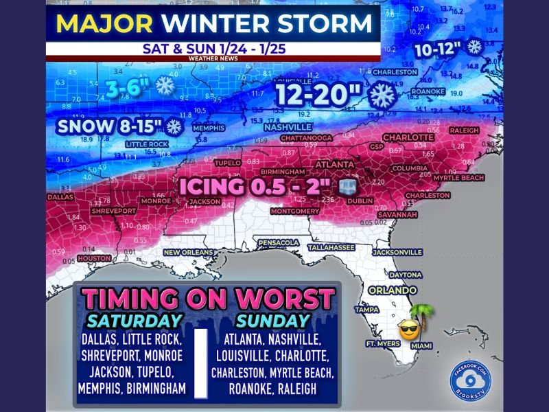
Meteorologists are emphasizing that this is not a typical Southern winter system. Ice — not snow totals — is the primary threat, and even modest ice amounts can cause long-lasting infrastructure damage across regions that are not built to handle it.
Why This Storm Is Especially Dangerous
Forecast maps show a wide swath of freezing rain, with 0.5 to 2 inches of ice accumulation possible in parts of Texas, Louisiana, Mississippi, Alabama, Georgia, and the Carolinas. In the South, as little as 0.25 inches of ice is considered high impact, meaning the upper-end projections could lead to tree failures, downed power lines, and prolonged outages.
Unlike snow, ice adds weight rapidly. Once trees and lines come down, roads can remain blocked long after precipitation ends, making travel dangerous even when conditions appear calm.
Snow Zone to the North Will Add to Disruptions
North of the ice corridor, heavy snow is expected, particularly across parts of Arkansas, Tennessee, and into the Carolinas, where 8 to 15 inches — and locally higher amounts — are possible. This sharp transition from snow to ice increases the risk of impassable highways, stranded motorists, and cascading travel delays.
Air travel disruptions are also likely, especially at major hubs such as Dallas–Fort Worth, Memphis, Nashville, Atlanta, and Charlotte, with cancellations expected to begin before the storm peaks and linger afterward.
Worst Timing and Travel Impacts
The most hazardous conditions are expected to develop Saturday and continue into Sunday, when freezing rain and sleet overlap with falling temperatures.
Key concerns include:
- Ice-covered highways becoming impassable
- Fallen trees and live power lines blocking roads
- Power outages lasting days rather than hours
- Emergency response delays due to blocked access
This is not a storm to “power through” while driving. Officials warn that ice shuts roads down not just from slick pavement, but from debris and infrastructure failure.
What Residents Should Do Now
Preparation is critical, especially in areas within the ice zone.
Important steps include:
- Charging phones, battery packs, and flashlights
- Stocking food and water for at least 2–3 days
- Fueling vehicles early
- Protecting pipes and bringing pets indoors
- Avoiding unnecessary travel once freezing rain begins
Flexibility will matter. Even short trips could become dangerous quickly if conditions deteriorate.
What Happens Next
After impacting the South this weekend, the storm system is expected to shift northeast early next week, potentially bringing significant impacts from Washington, D.C. to New York City.
Meteorologists stress that forecast details may still adjust, but confidence is increasing that this will be a high-impact winter storm remembered more for ice damage and outages than snowfall totals. Stay alert, monitor local updates, and prepare now before conditions worsen.
Have thoughts or local observations about how your area is preparing for this storm? Share your experience and stay informed with ongoing updates at NapervilleLocal.com.

I’ve lived in Naperville long enough to see how quickly our community changes — from new developments downtown to sudden shifts in our Midwest weather. Reporting on Naperville news and daily forecasts gives me the chance to keep neighbors informed about what really matters. My goal is simple: deliver clear, timely updates so you always know what’s happening in our city and what to expect from the skies above.