
Ohio Winter Storm Trend Intensifies as Colder Air Pushes Major Snowfall Northward Late January 25–26, 2026
Ohio — Forecast data is increasingly signaling that Ohio is moving into the center of a potential major winter storm, as a northward shift in the storm track places the state firmly in the crosshairs for significant snowfall late Saturday through Sunday, January 25–26, 2026. The latest trend highlights bigger snow totals moving north, bringing Ohio into a more impactful position than earlier forecasts suggested.
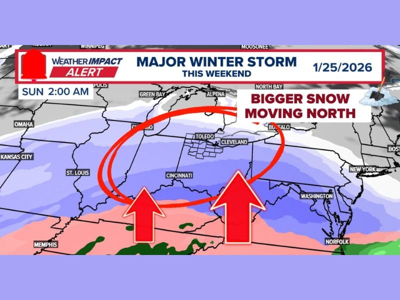
Northern Shift Places Ohio in the Core Impact Zone
The primary change shown in the data is a clear northern trend, which now places Ohio much closer to the heart of the storm system. Areas that were previously on the edge of heavier snowfall are now within a more concentrated snow band.
Key signals from the data include:
- Ohio now sits directly under expanding snowfall coverage
- The storm track has shifted north compared to earlier expectations
- The phrase “bigger snow moving north” reflects growing confidence in Ohio’s involvement
This shift significantly increases the likelihood of widespread travel disruptions across the state.
Storm Timing: Snow Arrives Late Saturday, Lasts Through Sunday
According to the forecast description, the system is also speeding up, which tightens the window for preparation. Snow is expected to begin late Saturday, continuing through much of Sunday.
Important timing details:
- Late Saturday: Snow begins to overspread Ohio
- Sunday: Snow continues for much of the day
- The duration supports several inches of accumulation
This extended period of snowfall raises concerns for road conditions, visibility, and prolonged impacts.
Cold Snow Increases Accumulation and Blowing Snow Risk
A critical detail in the forecast is the expectation of very cold snow, which is described as rare for the region. This type of snow sticks immediately and is more easily blown around by wind, compounding impacts.
The data highlights:
- Temperatures likely in the teens or even single digits
- Snow that accumulates quickly upon falling
- Increased potential for blowing and drifting snow
These factors suggest that conditions may deteriorate rapidly once snowfall begins.
Why Travel Impacts Could Be Significant
With several inches of snow possible, cold temperatures, and a prolonged snowfall window, travel across Ohio could become very difficult during the peak of the storm. Snow sticking immediately and blowing easily increases the chance of slick roads and reduced visibility, even if snowfall rates fluctuate.
The evolving forecast emphasizes impact potential rather than exact totals, as the northern shift remains the defining factor of this setup.
Main Takeaway From the Data
The central message from the given data is clear:
- Ohio is increasingly favored for a major snow event
- Storm trends are shifting north, not south
- Cold, fast-accumulating snow is the primary concern
Updates are expected as confidence continues to increase.
Readers can stay informed with continued winter weather coverage and updates at NapervilleLocal.com as this developing storm approaches.

I’ve lived in Naperville long enough to see how quickly our community changes — from new developments downtown to sudden shifts in our Midwest weather. Reporting on Naperville news and daily forecasts gives me the chance to keep neighbors informed about what really matters. My goal is simple: deliver clear, timely updates so you always know what’s happening in our city and what to expect from the skies above.