
Late-January Winter Storm Trend Sharpens as EURO and GFS Signal Very Heavy Snow Along a Shifting North–South Axis
Midwestern and Eastern United States — The latest EURO and GFS model runs are now largely aligned on the development of a very heavy late-January snowstorm, with differences focusing on where the heaviest snowfall band ultimately sets up rather than whether the storm occurs at all. The data clearly shows a high-impact winter storm scenario, with snowfall totals significant enough to cause major travel and infrastructure disruptions.
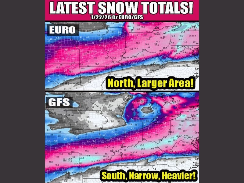
Model Agreement Confirms a High-Impact Snowstorm
The most important signal in the data is that both the EURO and GFS models now support a major snow event, reducing the likelihood of a last-minute collapse. While the models are not identical, their convergence this close to the event significantly raises forecast confidence.
Key points supported by the data:
- Both models show widespread double-digit snowfall potential
- Differences are limited to band placement and width
- The storm itself is no longer in question
This type of convergence strongly favors a significant winter weather outcome.
EURO Model: Broader, Farther-North Heavy Snow Zone
The EURO solution depicts a larger geographic footprint of heavy snow, extending the impact zone farther north. This scenario favors widespread heavy accumulations across a broad corridor, increasing the number of areas affected even if localized totals vary.
EURO characteristics shown in the image:
- Northward-expanded snowfall coverage
- Large areas receiving heavy totals
- Emphasis on coverage over extreme banding
GFS Model: Narrower but More Intense Southern Snow Band
In contrast, the GFS solution compresses the heaviest snowfall into a tighter southern corridor, but with locally higher snowfall amounts within that zone. This type of setup increases the risk of sharp cutoffs, where small shifts could dramatically change impacts.
GFS characteristics shown in the image:
- Narrower snowfall axis
- Higher localized snowfall totals
- Greater sensitivity to track and thermal changes
Cold Snow Profile Increases Accumulation Efficiency
Both models depict a cold-air-dominated system, which is critical. Cold snow sticks immediately, accumulates efficiently, and is more prone to blowing and drifting, compounding impacts even outside peak snowfall rates.
This raises the risk of:
- Rapid road deterioration
- Extended travel disruptions
- Snow remaining in place longer after the storm
Main Message From the Data
Based strictly on the image provided, the takeaway is clear:
- A major winter storm is highly likely
- Very heavy snowfall is supported by multiple models
- Uncertainty lies in north–south placement, not storm strength
- Cold temperatures will amplify impacts
This remains raw model data, but confidence is increasing as the event approaches.
Readers can continue following detailed winter storm analysis and updates at NapervilleLocal.com as the forecast becomes more refined.

I’ve lived in Naperville long enough to see how quickly our community changes — from new developments downtown to sudden shifts in our Midwest weather. Reporting on Naperville news and daily forecasts gives me the chance to keep neighbors informed about what really matters. My goal is simple: deliver clear, timely updates so you always know what’s happening in our city and what to expect from the skies above.