
Texas and Oklahoma Winter Storm Brings Heavy Snow to the Panhandle and Dangerous Sleet Setup for North Texas From Friday Night Through Sunday
TEXAS AND OKLAHOMA — Short-range forecast guidance continues to refine a high-impact winter storm expected to unfold from Friday night through Sunday, with very different hazards developing across Oklahoma, the Texas Panhandle, and North Texas. While colder northern areas remain locked into snow, locations farther south face a prolonged sleet and ice event driven by warm air aloft and falling surface temperatures.
Forecasters stress that this storm presents serious travel and safety concerns, particularly late Friday night through the weekend.
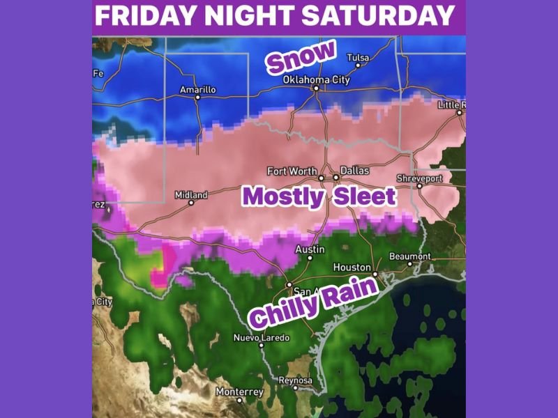
Snow Dominates From Oklahoma Into the Texas Panhandle
One of the most consistent signals in the guidance is a snow-dominated event from Oklahoma into the Texas Panhandle, where cold air remains entrenched for the entire storm.
Key impacts in this zone include:
- Mostly snow for the duration of the event
- Accumulations ranging from 6 to 10 inches
- Persistent subfreezing temperatures preventing changeover
These areas are expected to avoid significant icing issues, but snow-covered roads and reduced visibility will remain a concern through Saturday.
North Texas Transitions to Ice After Midnight Friday
Conditions change sharply farther south into North Texas, including the Dallas–Fort Worth Metroplex, where temperatures hover near freezing Friday evening before dropping rapidly overnight.
Timeline highlights include:
- Around 9 PM Friday: Temperatures approach freezing
- After midnight Friday: Roads begin turning icy
- Late Friday night into Saturday: Surface temperatures fall into the low 30s and upper 20s
Light rain Friday evening becomes far more hazardous after midnight, as freezing conditions take hold at the surface.
Sleet Becomes the Primary Threat Across the Metroplex
Forecast data shows a persistent warm layer aloft, a classic setup favoring sleet over snow. As precipitation falls through this warm nose and refreezes near the ground, significant sleet accumulation becomes possible.
Forecasters note:
- Most precipitation type will be sleet
- Freezing rain may mix in at times
- Several inches of sleet are not out of the question
- Thundersleet is possible due to strong dynamic lift
This type of precipitation is particularly dangerous because it accumulates quickly, bonds to pavement, and is difficult to treat.
Saturday Night Marks the Peak of the Storm
The most intense period of the storm is expected Saturday night, when sleet rates increase across North Texas and colder air continues to filter in.
Impacts during this phase may include:
- Rapid accumulation on roads and bridges
- Extremely hazardous travel
- Widespread icy surfaces even where snowfall is minimal
Forecasters caution that sleet accumulation alone can be just as disruptive as heavy snow, especially in urban areas.
Backside Snow and Arctic Air Follow on Sunday and Monday
As the surface low begins to pull away Sunday afternoon, colder air wraps in behind the system, creating a brief opportunity for snow on the backside of the storm.
Shortly after, a second surge of Arctic air arrives Monday morning, bringing the coldest conditions of the event.
Expected cold impacts include:
- Single-digit low temperatures
- Wind chills between -5 and -10 degrees
- Refreezing of untreated roads and surfaces
These conditions will prolong travel hazards even after precipitation ends.
Travel Conditions Expected to Be Dangerous All Weekend
Meteorologists strongly advise limiting travel after midnight Friday and throughout the weekend if possible.
Even experienced winter drivers may encounter:
- Unpredictable road conditions
- Reduced traction from sleet accumulation
- Rapid changes over short distances
This storm is not expected to be a short-lived inconvenience, but rather a multi-day winter weather event with compounding hazards.
For continued storm analysis, timing updates, and clear explanations of evolving winter threats, stay connected with NapervilleLocal.com.

I’ve lived in Naperville long enough to see how quickly our community changes — from new developments downtown to sudden shifts in our Midwest weather. Reporting on Naperville news and daily forecasts gives me the chance to keep neighbors informed about what really matters. My goal is simple: deliver clear, timely updates so you always know what’s happening in our city and what to expect from the skies above.