
United States Faces One of the Strongest Major Winter Storm Signals in Years as Widespread Impacts Loom From the Southern Plains to the East Coast
UNITED STATES — A remarkably strong and unusually expansive winter storm signal is emerging across the central and eastern United States, with forecast data indicating a very high probability of winter weather impacts over a massive portion of the country. Meteorologists note that this level of consistency and coverage has not been observed in many years, raising concerns that the upcoming event could become one of the most memorable winter storms in recent history.
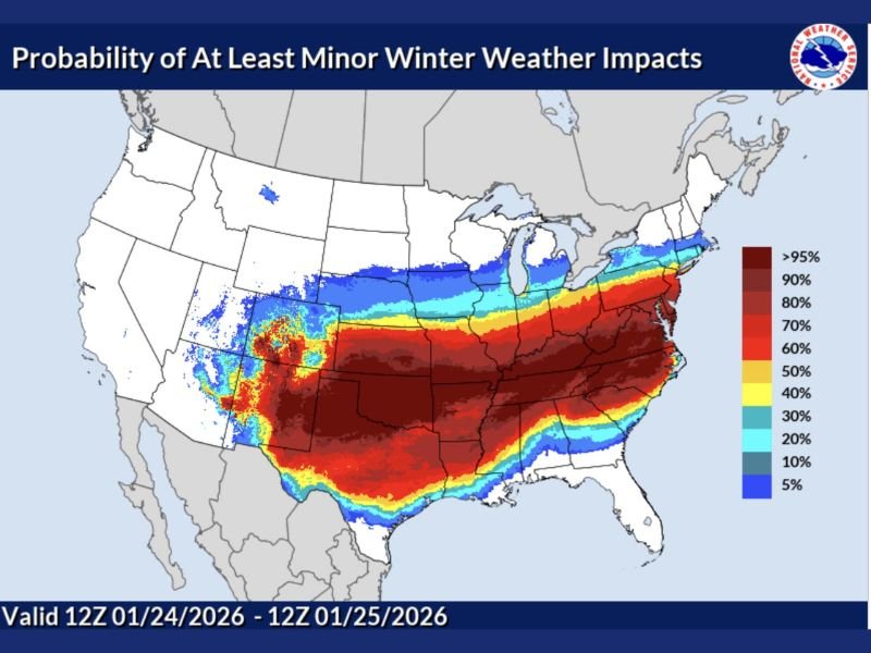
The probability outlook valid from 12Z January 24 through 12Z January 25 highlights an exceptionally broad corridor of expected winter impacts, stretching from the Southern Plains through the Ohio Valley and into the Mid-Atlantic and Northeast.
Probability Map Shows Rare, High-Confidence Winter Signal
The probability map illustrates the likelihood of at least minor winter weather impacts, with color gradients revealing how widespread and intense the signal has become.
Key observations include:
- Greater than 95% probability across large sections of the central Plains, Mid-South, Ohio Valley, and interior Mid-Atlantic
- 80% to 90% probability extending across much of the South-Central and Southeast regions
- 60% to 70% probability reaching well into parts of the Northeast
- A sharp northern gradient marking the boundary between winter impacts and cold-but-drier conditions
Meteorologists emphasize that probabilities this high, covering such a large area, are rare and significant, signaling strong agreement among forecast guidance.
Geographic Scope Highlights the Scale of the Threat
The spatial extent of the risk underscores how unusual and expansive this winter storm setup is.
Regions included within the highest probability zone span:
- The Southern Plains, where winter weather is less frequent but impacts can be severe
- The Lower and Mid-Mississippi Valley
- The Tennessee and Ohio Valleys
- The Mid-Atlantic, where cold air and moisture overlap
- Portions of the Northeastern United States
This breadth suggests a long, continuous storm track, rather than a localized or short-lived system.
Why This Signal Stands Out to Meteorologists
Forecasters describe this setup as the kind that imprints on winter climatology, not because of a single metric, but due to the combination of scale, consistency, and confidence.
Key factors making this event notable include:
- Extremely high probabilities over a multi-state area
- Strong model agreement on timing and placement
- A classic cold-air-meets-deep-moisture configuration
- Minimal signs of suppression or fragmentation
When probabilities exceed 70% to 90% across multiple regions, it indicates that disruptive winter conditions are very likely, even if exact precipitation types and totals vary locally.
Timing Suggests a Concentrated Impact Window
The valid period of the outlook points to a focused 24-hour window, during which winter impacts may intensify rapidly.
This timing favors:
- Widespread travel disruptions
- Icy and snow-covered roadways
- Potential strain on infrastructure
- Extended recovery time following the event
Because the signal covers such a large area simultaneously, emergency managers and transportation agencies may face competing regional demands.
Why This Could Be a Storm People Remember
Meteorologists caution that not every impactful winter storm becomes historic due to snowfall totals alone. Events become memorable when they combine:
- Geographic scale
- High confidence ahead of time
- Multi-region disruption
- Unusual intensity for certain areas
This system checks many of those boxes, making it the kind of storm that reshapes seasonal expectations and is referenced for years to come.
Residents across the impacted regions are urged to prepare for meaningful winter weather impacts, monitor updates closely, and avoid underestimating the scope of this event.
For continued analysis, forecast refinement, and clear explanations of evolving winter patterns, stay connected with NapervilleLocal.com.

I’ve lived in Naperville long enough to see how quickly our community changes — from new developments downtown to sudden shifts in our Midwest weather. Reporting on Naperville news and daily forecasts gives me the chance to keep neighbors informed about what really matters. My goal is simple: deliver clear, timely updates so you always know what’s happening in our city and what to expect from the skies above.