
Indiana Winter Storm Signal Strengthens as Northward Shift Raises Snow Potential From Indianapolis Southward Into Late January
INDIANA — A significant winter storm is becoming increasingly possible across Indiana, as forecast models continue to refine a powerful system expected to impact the central United States from Saturday through Monday, January 23–26. Meteorologists have been tracking this storm for over a week, watching a large surge of moisture and energy collide with an exceptionally strong Arctic high pressing south into the Midwest.
Over the last 24 hours, confidence has increased that Indiana now sits closer to the northern edge of the storm’s core, raising the likelihood of impactful snowfall, particularly across southern and central portions of the state.
Forecast Shift Brings Indiana Deeper Into the Storm Zone
Earlier forecasts focused heavily on the Mid-South taking the brunt of snow and ice, but recent model trends show a clear northward shift in the storm track.
This shift has been:
- Led by the European model
- Supported by the Canadian model
- Now confirmed by a northward adjustment in the American model
This alignment among major models significantly increases confidence that Indiana will be affected, rather than sitting just north of the main impact zone.
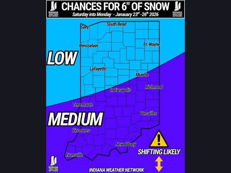
Snow Probability Map Highlights Regional Differences Across Indiana
The probability map for 6 inches of snow illustrates a sharp gradient across the state, underscoring how sensitive the forecast remains to further shifts.
Key regional signals include:
- Southern Indiana: Moderate probability of reaching 6 inches of snow, especially near Evansville, Vincennes, New Albany, and Versailles
- Central Indiana: Moderate and increasing probability, including areas near Indianapolis, Terre Haute, Muncie, and Richmond
- Northern Indiana: Lower probability, including Gary, South Bend, Lafayette, Rensselaer, and Fort Wayne, though chances are no longer negligible
Forecasters emphasize that even small additional northward shifts could quickly raise snow chances farther north.
Why Accumulation Forecasts Are Not Yet Locked In
While confidence is growing that snow will impact Indiana, meteorologists caution that it is still too early to assign specific accumulation totals.
Reasons for holding off include:
- Ongoing track uncertainty
- Sensitivity to thermal profiles
- The evolving interaction between moisture and Arctic air
Once the storm’s path becomes clearer, snowfall accumulation maps will be released, offering more precise guidance.
Timing Suggests a Multi-Day Winter Impact
Current guidance places the primary impact window between Saturday and Monday, with snow potential increasing as colder air becomes firmly established.
This timing raises concerns for:
- Weekend travel
- Extended snow-covered roads
- Lingering impacts into early next week
The prolonged nature of the event increases the likelihood of meaningful disruption, even if snowfall rates fluctuate.
Why Indiana Residents Should Pay Close Attention
This storm stands out not because of a single model run, but due to the consistency and persistence of the signal across multiple forecasting systems.
Meteorologists highlight:
- Increasing agreement among global models
- A strengthening Arctic air mass
- A growing snow signal for Indiana
- A forecast still trending toward higher impact
Together, these factors suggest Indiana may be facing one of its more notable winter weather events of the season.
Residents across the state should remain alert as additional data becomes available and forecasts are refined. For continued winter storm analysis and clearly explained forecast updates, stay connected with NapervilleLocal.com.

I’ve lived in Naperville long enough to see how quickly our community changes — from new developments downtown to sudden shifts in our Midwest weather. Reporting on Naperville news and daily forecasts gives me the chance to keep neighbors informed about what really matters. My goal is simple: deliver clear, timely updates so you always know what’s happening in our city and what to expect from the skies above.