
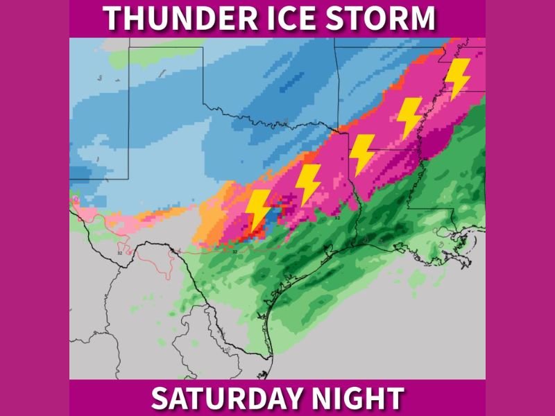
Thunder-Ice Winter Storm May Trigger Lightning, Freezing Rain, and Sleet Across East Texas, North Louisiana, Arkansas, and Northern Mississippi Saturday Night
UNITED STATES — A rare and potentially dangerous “thunder-ice” winter storm scenario is coming into focus for parts of the Lower Mississippi Valley and Ark-La-Tex region, where freezing rain and sleet may fall alongside lightning and thunder late Saturday night. Meteorologists say this unusual setup could make the storm more hazardous and unsettling than a typical winter weather event, especially for travel and power infrastructure.
What Makes This Storm Unusual
Forecast data shows a conflicting atmospheric setup, where surface temperatures remain below freezing while warmer, unstable air surges overhead. This creates the potential for thunderstorms embedded within winter precipitation, a phenomenon known as thundersleet or thunder-ice.
Key atmospheric factors include:
- Sub-freezing surface temperatures
- Strong warm air advection aloft
- Elevated instability capable of producing lightning
- Deep moisture feeding into the system
This combination allows electrified storms to develop even as ice accumulates on roads, trees, and power lines.
Regions Most at Risk
Based on the data shown, the highest risk zone for thunder-ice includes:
- East Texas
- Northern Louisiana
- Southern and Central Arkansas
- Northern Mississippi
These areas sit within a transition corridor where heavy freezing rain or sleet overlaps with elevated thunderstorm energy, increasing the chance of brief lightning bursts during intense icing periods.
Timing of the Threat
The most active phase of the storm is expected to unfold Saturday night, when precipitation intensifies and instability peaks.
During this window:
- Freezing rain and sleet rates may increase
- Lightning and thunder could occur within ice bands
- Road conditions may rapidly deteriorate
- Ice accumulation could accelerate in short bursts
Because freezing rain is often more damaging than snow, even short-lived heavy icing can cause tree damage, power outages, and impassable roads.
Why Lightning During Ice Matters
Lightning within a winter storm signals strong upward motion, which can lead to:
- Heavier precipitation rates
- Faster ice accumulation
- Greater stress on power infrastructure
- Sudden drops in visibility for drivers
This makes thunder-ice storms especially dangerous, as conditions can worsen much faster than expected.
What Residents Should Be Prepared For
Residents in the affected regions should be prepared for:
- Treacherous travel conditions
- Rapid ice buildup on untreated roads
- Possible power outages
- Sudden bursts of intense precipitation
Even areas that typically see winter weather should treat this event seriously due to the unusual intensity and volatility of the setup.
Forecast Confidence and Final Thoughts
While the exact placement of the thunder-ice corridor may still shift slightly, confidence is growing that parts of East Texas, North Louisiana, Arkansas, and northern Mississippi will experience a high-impact winter storm unlike a typical freezing rain event.
This is the kind of storm that can catch people off guard, not because of snow totals, but because of how quickly and violently conditions can deteriorate once freezing rain, sleet, and lightning combine.
Stay weather-aware, avoid unnecessary travel during the storm window, and follow continuing updates as this rare winter setup evolves. For continued coverage and detailed breakdowns of major weather events nationwide, stay connected with NapervilleLocal.com.

I’ve lived in Naperville long enough to see how quickly our community changes — from new developments downtown to sudden shifts in our Midwest weather. Reporting on Naperville news and daily forecasts gives me the chance to keep neighbors informed about what really matters. My goal is simple: deliver clear, timely updates so you always know what’s happening in our city and what to expect from the skies above.