
Half-Inch Ice Threshold Raises Power Grid Failure Risk as Winter Storm Threatens Widespread Outages Across Impacted Regions
UNITED STATES — As confidence grows in a high-impact winter storm capable of producing significant ice accumulation, forecasters are increasingly focused on one critical benchmark: ½ inch of ice. Once ice totals approach or exceed this level, infrastructure impacts escalate rapidly, shifting the threat from slippery roads to widespread power outages, falling trees, and prolonged recovery efforts.
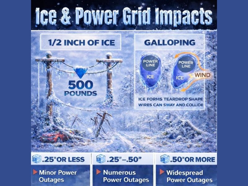
Why ½ Inch of Ice Is a Breaking Point
Ice accumulation does not increase impacts in a linear way. Instead, damage accelerates sharply once ice nears 0.50 inches.
At around ½ inch of ice:
- Each span of power line can take on hundreds of pounds of added weight
- Ice forms a teardrop or “galloping” shape on lines, increasing wind resistance
- Even modest wind can cause lines to sway, collide, or snap
- Utility poles may tilt, break, or collapse entirely
In many scenarios, a single iced power line can hold 500 pounds or more of additional load, far beyond what the system is designed to withstand.
Power Outages: How Ice Brings the Grid Down
Ice storms damage power systems through three primary mechanisms:
- Direct line overload from ice weight
- Wind-induced galloping, where iced lines swing violently
- Tree and limb failures, with ice-laden branches crashing onto lines
Unlike wind-only storms, ice events tend to cause slower restoration, especially when freezing temperatures prevent ice from melting.
Tree Damage Adds to the Hazard
Trees are particularly vulnerable during ice storms:
- Ice-coated branches snap under their own weight
- Entire trees can uproot or fall
- Damage occurs not just on power lines, but also:
- Roadways
- Homes
- Parked vehicles
When ice persists for days, cleanup operations become dangerous and time-consuming, further delaying power restoration.
Ice Amounts and Expected Impacts
Based on historical storm data, impacts generally scale as follows:
- 0.25 inches or less
- Scattered or minor power outages
- Localized tree damage
- 0.25 to 0.50 inches
- Numerous power outages
- Significant tree and limb failures
- Dangerous travel conditions
- 0.50 inches or more
- Widespread power outages
- Structural damage to power infrastructure
- Prolonged outages lasting days or longer
Cold Air Could Prolong Impacts
A major concern with this setup is incoming freezing air behind the storm. If temperatures remain below freezing:
- Ice will not melt quickly
- Fallen lines and trees will remain frozen in place
- Restoration efforts may slow dramatically
- Some areas could experience multi-day outages
This is especially problematic across large geographic areas, where utility crews must prioritize the most critical failures first.
What Residents Should Prepare For
Residents in ice-prone regions should prepare now for:
- Extended power outages
- Loss of heat
- Blocked or impassable roads
- Delayed emergency response times
Emergency plans should include:
- Backup heat sources (used safely)
- Fully charged devices
- Food and water supplies
- Avoiding travel once ice begins accumulating
Bottom Line
Ice storms are among the most destructive winter weather events, not because of snowfall totals, but because of how ice loads infrastructure beyond its limits. With forecasts increasingly signaling ice amounts near or above the ½-inch danger threshold, the risk of widespread outages and long-lasting disruptions is very real.
NapervilleLocal.com will continue tracking winter storm threats, ice accumulation forecasts, and power outage risks across the country. Stay connected with us for ongoing updates, safety guidance, and clear explanations of what these evolving forecasts mean for you and your community.

I’ve lived in Naperville long enough to see how quickly our community changes — from new developments downtown to sudden shifts in our Midwest weather. Reporting on Naperville news and daily forecasts gives me the chance to keep neighbors informed about what really matters. My goal is simple: deliver clear, timely updates so you always know what’s happening in our city and what to expect from the skies above.