
Florida Snow Tease Emerges in Long-Range Models as Cold Gulf System Hints at Rare Winter Setup
FLORIDA — Long-range weather models are beginning to tease the possibility of snow across parts of Florida next weekend, an unusual signal that has sparked early chatter among forecasters and weather watchers, even as confidence remains low this far out.
While rain and cold appear more likely at this stage, the overall setup — involving a Gulf-based system interacting with colder air — is enough to keep the conversation alive for now.
What the Models Are Suggesting Right Now
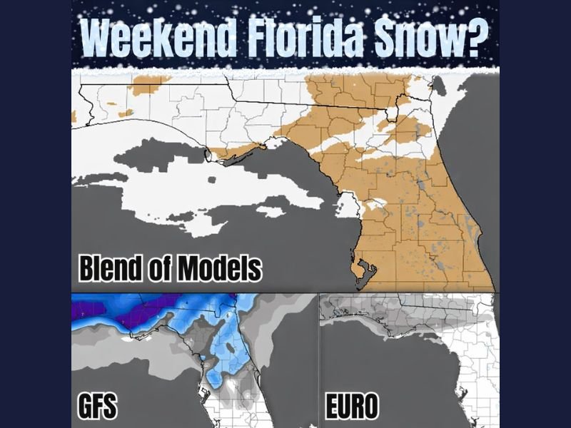
Recent runs of major forecast models, including GFS and European guidance, are showing a broad cold pattern across the Southeast with precipitation overlapping unusually cool air over northern Florida and the Panhandle.
At this range:
- Rain is the most likely outcome
- Temperatures appear cold enough to raise eyebrows
- Snow signals remain weak and inconsistent
Forecasters emphasize that this is not a forecast, but rather an early signal worth monitoring.
Why Snow in Florida Is So Difficult
For snow to occur in Florida, several elements must align perfectly:
- Cold air must be deep and sustained
- Moisture must arrive at the right time
- Surface temperatures must stay cold enough during precipitation
Even slight changes in storm track, timing, or temperature profiles can shift outcomes from snow to cold rain or simply dry conditions.
Gulf Setup Is the Key Ingredient
What makes this scenario notable is the potential Gulf system, which can occasionally provide enough moisture to interact with marginal cold air. Historically, these setups are rare but not impossible — and often don’t become clear until much closer to the event.
At this point, the signals are best described as “teasing” rather than forecasting.
Too Early for Planning, but Worth Watching
Meteorologists caution that it is far too early to plan for snow, chase flakes, or expect impacts. However, subtle model trends over the next several days will determine whether:
- Cold air strengthens
- Precipitation timing improves
- Snow potential fades entirely
Until then, expectations should remain grounded.
What Residents Should Expect for Now
For most of Florida, the most realistic outcome remains:
- Cold weather
- Periods of rain
- Possible wintry weather north of the state line
Any true winter precipitation would most likely be limited to far northern Florida or the Panhandle, if it happens at all.
Have you ever experienced snow in Florida, or do you think this system will fizzle out? Share your thoughts and keep following NapervilleLocal.com for clear, no-hype updates as the forecast evolves.

I’ve lived in Naperville long enough to see how quickly our community changes — from new developments downtown to sudden shifts in our Midwest weather. Reporting on Naperville news and daily forecasts gives me the chance to keep neighbors informed about what really matters. My goal is simple: deliver clear, timely updates so you always know what’s happening in our city and what to expect from the skies above.