
Florida Braces for Extreme Temperature Whiplash as 80s Heat Gives Way to Near-Freezing Cold Within 48 Hours
FLORIDA — Residents across Florida are being warned to prepare for an unusually dramatic temperature swing, as summer-like warmth this Sunday will be followed by a sharp Arctic cold blast early next week, creating one of the most abrupt weather reversals the state has seen this season.
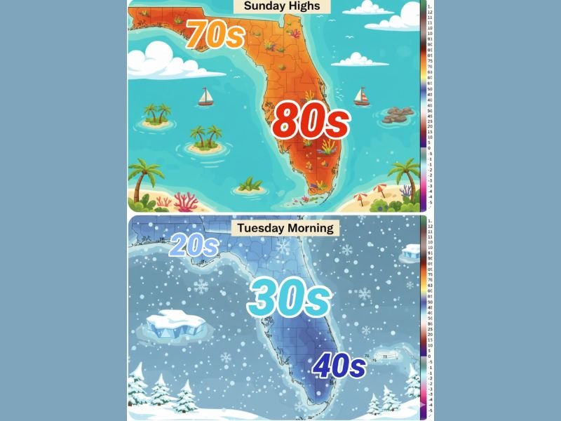
Forecasters say highs in the 70s and 80s on Sunday will collapse into much colder conditions by Tuesday morning, with some parts of the state experiencing temperature drops of nearly 50 degrees in less than two days.
Sunday Heat Pushes Florida Back Into Summer Mode
On Sunday, much of Florida will feel more like late spring or early summer.
High temperatures are expected to reach:
- Upper 70s across North and Central Florida
- Low to mid-80s across South Florida
- Heat index values approaching 90°F in the southern peninsula due to humidity
The warmth will be widespread, encouraging beach trips, outdoor activities, and short-sleeve weather statewide. Meteorologists describe this as a classic warm surge ahead of a powerful cold front, with warm air firmly in place before conditions rapidly change.
Powerful Cold Front Arrives Monday
That warm pattern will not last long.
A strong cold front is expected to sweep through Florida on Monday, pushing colder air rapidly southward. As the front passes, temperatures will begin dropping sharply, especially overnight.
By Monday night, conditions will feel drastically different:
- Brisk north winds will develop
- Temperatures will fall quickly after sunset
- Humidity levels will drop, making the cold feel sharper
This transition is expected to happen fast, leaving little time for residents to adjust.
Tuesday Morning Brings Shockingly Cold Conditions
By early Tuesday morning, Florida will wake up to winter-like temperatures statewide.
Forecast projections show:
- 20s across parts of North Florida
- 30s across Central Florida
- 40s in much of South Florida
In some locations, Tuesday morning temperatures could be 45 to 50 degrees colder than Sunday afternoon, an extreme swing by Florida standards. While hard freezes are most likely in northern parts of the state, even southern areas will feel unusually cold for late January.
Cold Air Lingers Into Early February
Meteorologists say this will not be a brief cold snap.
Model guidance suggests below-average temperatures may persist for several days, with limited warming until after February 5. The lingering cold is being reinforced by back-to-back Arctic air intrusions, keeping Florida locked in a cooler-than-normal pattern.
Residents are being advised to:
- Prepare warm clothing now
- Check heating systems
- Protect sensitive plants and pets
- Be cautious of cold-sensitive wildlife, including iguanas that may become immobile in cold weather
A Rare Florida Weather Flip
Weather experts note that temperature swings of this magnitude are uncommon, even for Florida’s volatile winter patterns. The rapid transition from near-record warmth to winter cold highlights the strength of the incoming Arctic air mass.
As one meteorologist put it, this is not just a weather change — it’s a full seasonal flip in less than 48 hours. Residents are encouraged to stay alert, monitor local forecasts, and prepare for a week that will feel anything but typical for Florida.
Have you ever experienced a temperature swing this extreme in Florida? Share your thoughts and stay updated with the latest regional weather coverage on NapervilleLocal.com.

I’ve lived in Naperville long enough to see how quickly our community changes — from new developments downtown to sudden shifts in our Midwest weather. Reporting on Naperville news and daily forecasts gives me the chance to keep neighbors informed about what really matters. My goal is simple: deliver clear, timely updates so you always know what’s happening in our city and what to expect from the skies above.