
Florida Braces for Rare Arctic Blast as Bomb Cyclone Drives Wind Chills Into the Single Digits and Teens
FLORIDA — A powerful and unusually intense winter pattern is setting up across the Eastern United States, and Florida is now directly in the path of Arctic air driven south by a developing bomb cyclone along the East Coast. Meteorologists say this is not hype — multiple forecast models agree that a sharp and dangerous cold surge will arrive late Saturday night into Sunday morning, bringing some of the coldest wind chills Florida has seen in years.
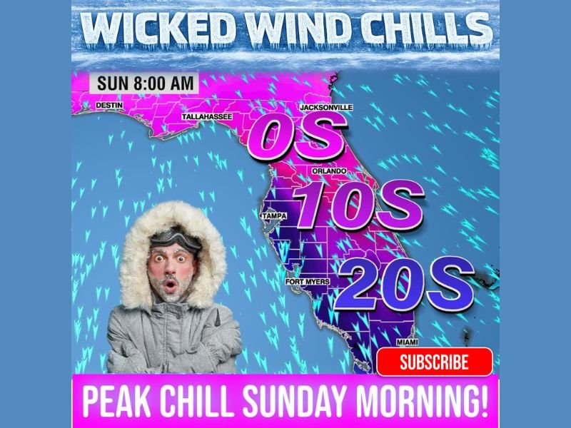
How Cold It Will Feel Across Florida
Forecast data shows wind chill values plunging far below what most Floridians are accustomed to, especially during the early morning hours Sunday.
- North Florida: Wind chills may drop into the single digits, with actual low temperatures near 20°F
- Central Florida (Tampa–Orlando corridor): Wind chills in the teens, especially near the I-4 corridor
- South Florida: Wind chills falling into the 20s, with actual lows near 35°F as far south as Miami
Strong northerly winds behind the system will make conditions feel significantly colder than the thermometer suggests, increasing the risk of cold-related impacts.
Why This Cold Event Is So Unusual
This cold snap is being fueled by a rapidly strengthening bomb cyclone along the Eastern Seaboard, a storm system that intensifies extremely quickly and acts like a vacuum, pulling Arctic air deep into the Southeast.
Meteorologists note that several independent weather models, not just one, are showing this scenario — adding confidence that Florida will experience a brief but intense Arctic intrusion, not just a cool down.
Peak Impact Timing
The most dangerous cold conditions are expected early Sunday morning, roughly around 8:00 a.m., when winds remain strong and temperatures bottom out. While afternoon highs will recover somewhat, the morning hours pose the greatest risk for exposed skin, pets, and sensitive plants.
Potential Impacts Residents Should Prepare For
Even though Florida is not expected to see snow or ice, the cold itself can still cause problems:
- Risk to pets, plants, and outdoor plumbing
- Cold stress for vulnerable populations
- Hazardous conditions for anyone outdoors for extended periods
- Agricultural concerns, especially in northern and central parts of the state
Residents are urged to dress in layers, limit early-morning outdoor exposure, protect pets and pipes, and use heaters safely.
What Happens Next
This Arctic blast is expected to be short-lived, but it underscores how volatile the current winter pattern has become across the country. Meteorologists continue to monitor the broader setup, as additional cold shots remain possible in the days ahead.
For continued coverage of major weather events and how national patterns can impact local communities, stay with NapervilleLocal.com and share what conditions you’re experiencing where you live.

I’ve lived in Naperville long enough to see how quickly our community changes — from new developments downtown to sudden shifts in our Midwest weather. Reporting on Naperville news and daily forecasts gives me the chance to keep neighbors informed about what really matters. My goal is simple: deliver clear, timely updates so you always know what’s happening in our city and what to expect from the skies above.