
Florida Snow Watch Issued as EURO Model Signals Narrow Flurry Window Near Tampa Bay Amid Extreme Cold
FLORIDA — Meteorologists are urging residents to manage expectations as forecast guidance continues to hint at a rare but highly uncertain chance of snow flurries across parts of Florida this weekend, particularly near the Tampa Bay area, while a surge of extreme cold settles into the state.
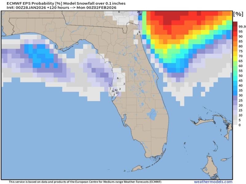
The latest EURO model guidance continues to flirt with the idea of frozen precipitation, showing a narrow setup where cold air, moisture, and timing briefly align. While Florida snow remains an extreme outlier event, forecasters stress that the probability is no longer zero, prompting cautious monitoring rather than outright dismissal.
What the Models Are Showing
The EURO ensemble probability data indicates a limited chance of snowfall exceeding 0.1 inches across small portions of Florida, primarily near coastal areas influenced by Gulf moisture. This scenario relies on a Gulf-effect process, similar to lake-effect snow, where cold air moving over warmer waters generates localized precipitation bands.
Forecast confidence remains low, and most model members favor cold rain rather than snow. However, a small subset continues to support brief flurries if temperatures cool just enough during peak precipitation.
Where Flurries Are Most Likely
The highest conditional risk is focused around the Tampa Bay region, with nearby coastal areas seeing the best overlap of cold air aloft and moisture. Inland locations and southern Florida remain largely outside the zone of concern due to warmer surface temperatures.
Even in favored areas, any snow would be short-lived, light, and highly localized, with no meaningful accumulation expected.
Timing of the Potential Event
The narrow window for any snowflakes appears to be late Saturday night into early Sunday morning, when overnight cooling reaches its peak. Surface temperatures during this time may briefly approach the threshold needed for flakes to survive to ground level.
Once daylight returns, temperatures are expected to rebound just enough to eliminate any remaining frozen precipitation risk.
Why Expectations Should Remain Low
Florida’s climate history strongly favors disappointment when snow enters the forecast discussion. Ground temperatures remain warm, atmospheric profiles are marginal, and precipitation intensity is expected to be light. The most likely outcome remains cold rain, followed by clearing skies and lingering chill.
Forecasters emphasize that excitement often builds faster than atmospheric reality in these setups, which frequently end without observable snow.
Extreme Cold Still the Main Story
Regardless of snow outcomes, extreme cold is firmly on the way. Temperatures across Florida will drop well below seasonal norms, marking another unusual chapter in the 2026 winter season. Cold-weather precautions will be necessary even if snow never materializes.
Florida residents are encouraged to stay informed, protect pets and plants, and prepare for unseasonably cold conditions. For continued coverage of major weather developments and why they matter nationally, visit NapervilleLocal.com for the latest updates.

I’ve lived in Naperville long enough to see how quickly our community changes — from new developments downtown to sudden shifts in our Midwest weather. Reporting on Naperville news and daily forecasts gives me the chance to keep neighbors informed about what really matters. My goal is simple: deliver clear, timely updates so you always know what’s happening in our city and what to expect from the skies above.